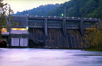
Watauga River
| Watauga River | ||
|
Watauga River near Valle Crucis |
||
| Data | ||
| Water code | US : 1327321 | |
| location | North Carolina , Tennessee (USA) | |
| River system | Mississippi River | |
| Drain over | South Fork Holston River → Holston River → Tennessee River → Ohio River → Mississippi River → Gulf of Mexico | |
| source | in Watauga County 36 ° 7 ′ 25 ″ N , 81 ° 50 ′ 7 ″ W. |
|
| muzzle | in the South Fork Holston River near Kingsport Coordinates: 36 ° 26 ′ 51 " N , 82 ° 25 ′ 21" W 36 ° 26 ′ 51 " N , 82 ° 25 ′ 21" W |
|
| Mouth height |
422 m
|
|
| length | 97 km | |
| Left tributaries | Doe River | |
| Reservoirs flowed through | Watauga Lake , Wilbur Lake | |
|
Watauga River below the TVA Wilbur Dam |
||
|
Kakakreiber at the Bee Cliff Rapids - "The Big Hole" |
||
|
White water rafting at "The Big Hole" in the Bee Cliff Rapids |
||
The Watauga River is a river located in North Carolina and eastern Tennessee .
It has a length of 97 km. Its source is on the slopes of Grandfather Mountain and Peak Mountain in Watauga County .
Hydrography
The Watauga River is formed by the confluence of the Shanty Spring Branch and Green Ridge Branch in Watauga County. The river crosses the Tennessee border into Johnson County . There it is dammed by the Watauga Dam , which is operated by the Tennessee Valley Authority (TVA), to form the 26 km² Watauga Lake . Two other rivers flow into the reservoir: Elk River and Roan Creek .
Tennessee State Route 67 crosses Watauga Lake at Butler Bridge . The Appalachian Trail runs over the Watauga Dam.
Below the Watauga Dam lies the horseshoe section of the river. Here is another dam, the Wilbur Dam , also operated by TVA, which forms a much smaller reservoir, Wilbur Lake . In the dry summer months, about 3.7 m³ / s of retained water flows into the Watauga River.
The Watauga River flows mostly north and later west. He reaches Elizabethton , where he takes up the Doe River . Further downstream is the old TVA Watauga steam power plant. Then the Watauga River meets the South Fork Holston River.
history
The word "Watauga" comes from the Cherokee , who named several places after it, including today's Elizabethton. This was then known as "Watauga Old Fields" and was first visited by Daniel Boone and James Robertson in 1759. A larger Cherokee settlement called Watauga was on the Little Tennessee River near Franklin . The first dam in Tennessee that was used to generate electricity was built on the site of Wilbur Dam. This was built between 1909 and 1912 by the Tennessee Electric Power Company (acquired by TVA in the late 1930s). Elizabethton was nicknamed the "City of Power" because of its early access to electricity (from Wilbur Dam).
free time activities
Whitewater - rafting , whitewater kayaking and whitewater canoeing , fly-fishing and fishing are popular activities on the Watauga River. Rainbow trout , brown trout and rock bass can all be caught in the Watauga River.
Whitewater
The Watauga River below the two TVA dams attracts many commercial rafting outfitters from northeast Tennessee and western North Carolina during the summer months. Commercial fishing tours on the river run year round.
The Bee Cliff Rapids with a difficulty level of II + are located between Wilbur Dam and Siam Bridge southeast of Elizabethton on the Watauga River.
Commercial whitewater tours typically start at Carter County's put-in, just downstream from TVA Wilbur Dam. A popular end point ("take-out") is 2 to 2½ hours downstream (depending on the amount of water in the river) at the "Blackbottom riverside portion of the city linear trail park" in Elizabethton. The distance covered is 7 miles. The route can be divided into the following sections:
| Wilbur Dam - Bee Cliff Rapids | - 15 minutes. |
| Wilbur Dam - Siam Bridge | - 45 min. |
| Wilbur Dam - Hunter Bridge (TWRA put-in / take out) | - 75 min. |
| Wilbur Dam - Gilbert Peters Bridge, US 19-E in Elizabethton | - 105 min. |
| Wilbur Dam - Bristol Bridge in Elizabethton | - 135 min. |
The Watauga River offers a section of the river above Watauga Lake with the difficulty level IV-V, which is popular with experienced whitewater kayakers. However, the navigability of this section requires a sufficient amount of water in the river, which is only guaranteed after heavy rainfall.
TVA Recreation Areas
The Tennessee Valley Authority maintains a public campsite below the Watauga Dam.
Weather conditions
The Tennessee Valley Authority (TVA) regulates the amount of water in the Watauga River. It drains water from its two reservoirs. The TVA guarantees a minimum amount of water, so that commercial white water rafting companies switch to the Watauga River from other rivers (e.g. the Nolichucky River ), which sometimes have too little water during the summer season.
See also
Web links
Individual evidence
- ^ Watauga River in the Geographic Names Information System of the United States Geological Survey
- ↑ http://www.tnfish.org/ReservoirLakeInformation_TWRA/TWRA_WataugaReservoirInformation.htm TWRA - Tennessee Wildlife Resources Agency - Watauga Reservoir.
- ↑ http://lakeinfo.tva.gov/htbin/lakeinfo?site=WIH&DataType=All&submit=View%2Binfo TVA. Wilbur Dam.
- ↑ Bee Cliff in the United States Geological Survey's Geographic Names Information System
- ↑ http://www.americanwhitewater.org/content/River_detail_id_1794 American Whitewater NWRI - Watauga Guys Ford Bridge to Watauga Lake.
- ↑ http://www.tva.gov/river/recreation/camping.htm#watauga TVA: Camping and Recreation Areas - Watauga Reservoir: Watauga Dam Tailwater Campground.
- ↑ http://www.johnsoncitypress.com/Detail.php?Cat=LOCALNEWS&ID=64611 Nolichucky: High water temporarily strands campers; rafting company expects boon in business.


