Waterbury (Village)
| Waterbury | ||
|---|---|---|
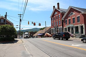
 Downtown Waterbury |
||
| Location in Vermont | ||
|
|
||
| Basic data | ||
| Foundation : | 1882 | |
| State : | United States | |
| State : | Vermont | |
| County : | Washington County | |
| Coordinates : | 44 ° 20 ′ N , 72 ° 45 ′ W | |
| Time zone : | Eastern ( UTC − 5 / −4 ) | |
| Residents : | 1,763 (as of 2010) | |
| Population density : | 359.8 inhabitants per km 2 | |
| Area : | 5.0 km 2 (approx. 2 mi 2 ) of which 4.9 km 2 (approx. 2 mi 2 ) are land |
|
| Height : | 130 m | |
| Postcodes : | 05671, 05676 | |
| Area code : | +1 802 | |
| FIPS : | 50-76900 | |
| GNIS ID : | 1460075 | |
| Website : | waterburyvt.com | |
Waterbury is a village in the town of Waterbury in Washington County of the state of Vermont in the United States with 1763 inhabitants (according to the 2010 census). Waterbury is south of the town of Waterbury. North of the Winooski River , which favored the settlement through its tributaries, which were well suited for the operation of mills. The administrations of the town and the village were merged in 2017, so that since then both areas have been administered together. The Interstate 89 runs from northwest to southeast through the Village to their parallel the US Highway 2 , he branches off the Vermont State Route 100 in a northeasterly direction. The interstate follows the course of the Winooski River.
history
Waterbury was declared a settlement on June 7, 1763. Settlement of the area started in 1784. The constituent assembly of the town was held on March 31, 1790 and the politically independent municipality was founded. The Village Waterbury was granted independent rights in 1882.
The settlement in the Village of Waterbury initially benefited from the favorable location on the Winooski River and its tributaries such as the Graves Brook , also called Thatcher's Brook , which enabled the operation of watermills and thus the settlement of industry. The Mill Village was created . In 1979, the Mill Village district belonging to Village Waterbury was listed on the National Register of Historic Places .
When it was connected to the railway network in 1849, the center of the village moved south, away from the Mill Village and near the railway depot. In the middle of the 19th century, commercial, industrial and residential areas were created there. At the end of the century, Waterbury's prosperous industries, created by the improved transport method of the railroad, resulted in further expansion of the commercial and residential areas. The Waterbury Village Historic District was added to the National Register of Historic Places in 1978 . It includes more than 200 buildings and structures in different styles from the 19th and 20th centuries.
The Vermont State Hospital , also known as the Vermont State Asylum for the Insane , was a village mental health institution built in 1890 to deal with the overcrowding of the privately operated Vermont Asylum for the Insane in Brattleboro, now known as the Brattleboro Retreat . Originally intended to treat criminal psychiatric patients, the hospital eventually admitted patients with a variety of problems including mild to severe intellectual disabilities, epilepsy, depression, alcoholism, and senility. The hospital campus, which now houses various other government offices, was added to the National Register of Historic Places in 2016 .
Population development
| year | 1800 | 1810 | 1820 | 1830 | 1840 | 1850 | 1860 | 1870 | 1880 | 1890 |
|---|---|---|---|---|---|---|---|---|---|---|
| Residents | 756 | 955 | ||||||||
| year | 1900 | 1910 | 1920 | 1930 | 1940 | 1950 | 1960 | 1970 | 1980 | 1990 |
| Residents | 1597 | 1377 | 1515 | 1776 | 3074 | 3153 | 2984 | 2840 | 1892 | 1702 |
| year | 2000 | 2010 | 2020 | 2030 | 2040 | 2050 | 2060 | 2070 | 2080 | 2090 |
| Residents | 1706 | 1763 |
Waterbury Village, Vermont census result
literature
- Zadock Thompson: History of Vermont, natural, civil and statistical, in three parts . 3rd volume. Chauncey Goodrich, Burlington 1842, p. 182 f . ( limited preview in Google Book search).
Web links
- official website of the municipality
- Entry on City-Data.com
- Entry on VirtualVermont (English) ( Memento from July 13, 2017 in the Internet Archive )
Individual evidence
- ^ Waterbury in the United States Geological Survey's Geographic Names Information System , accessed October 31, 2017
- ↑ Population data from the 2010 US Census in the American Factfinder
- ^ Village of Waterbury Votes to Dissolve Into Town of Waterbury . In: MYCHAMPLAINVALLEY . 2017 ( mychamplainvalley.com ).
- ↑ Waterbury, Vermont (VT 05676, 05677) profiles: population, maps, real estate, averages, homes, statistics, relocation, travel, jobs, hospitals, schools, crime, moving, houses, news, sex offenders. In: city-data.com. www.city-data.com, accessed on November 11, 2017 (English).
- ↑ Asset Detail. In: nps.gov. npgallery.nps.gov, accessed on November 11, 2017 .
- ^ Waterbury Village Historic District. In: nps.gov. Retrieved November 11, 2017 .
- ↑ Asset Detail. In: nps.gov. npgallery.nps.gov, accessed on November 11, 2017 .
- ^ What is Eugenics ?: Eugenics Project: A Documentary History, UVM. In: and much more edu. Retrieved November 11, 2017 .
- ^ Vermont State Hospital Historic District. In: nps.gov. Retrieved November 11, 2017 .
- ↑ Population 1880–2010 according to census results


