Weilheim (Hechingen)
|
Weilheim
City of Hechingen
|
|
|---|---|
| Coordinates: 48 ° 21 ′ 0 ″ N , 8 ° 54 ′ 54 ″ E | |
| Height : | 504 m above sea level NN |
| Area : | 6.94 km² |
| Residents : | 717 (December 31, 2015) |
| Population density : | 103 inhabitants / km² |
| Incorporation : | April 1, 1972 |
| Postal code : | 72379 |
| Area code : | 07471 |
|
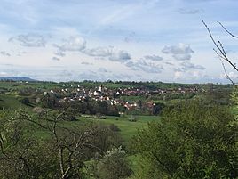
East view of Weilheim
|
|
Weilheim is a district of Hechingen in the Zollernalbkreis in Baden-Württemberg ( Germany ).
geography
Weilheim is about four kilometers west of the city center. The district area of the place is 694 hectares.
history
Weilheim was first mentioned in 1275, it had a parish church with an old Marian patronage early on, to which Grosselfingen and Wessingen also belonged. The village was always zollerisch and had to take over the protection of the county and the castle of Hohenzollern against the west. Hence the pronounced defensive character of the Church of the Visitation of the Virgin Mary and the cemetery. The church tower with two meter thick walls, loopholes and an earlier entrance five meters high was free until the church was expanded in 1767.
During the regional reform in Baden-Württemberg , Weilheim was incorporated into the city of Hechingen on April 1, 1972.
traffic
Local public transport is guaranteed by the Neckar-Alb-Danube transport association (naldo). The district is located in honeycomb 332.
Sports
Weilheim has a sports club that was founded in 1963. SV Weilheim 1963 eV plays in the regional league .
Web links
Individual evidence
- ↑ Max Miller , Gerhard Taddey (ed.): Handbook of the historical sites of Germany . Volume 6: Baden-Württemberg (= Kröner's pocket edition . Volume 276). 2nd, improved and enlarged edition. Kröner, Stuttgart 1980, ISBN 3-520-27602-X , p. 866.
- ^ Federal Statistical Office (ed.): Historical municipality directory for the Federal Republic of Germany. Name, border and key number changes in municipalities, counties and administrative districts from May 27, 1970 to December 31, 1982 . W. Kohlhammer, Stuttgart / Mainz 1983, ISBN 3-17-003263-1 , p. 528 .


