Werder (Märkisch Linden)
|
Werder
Municipality Märkisch Linden
Coordinates: 52 ° 55 ′ 4 " N , 12 ° 42 ′ 30" E
|
|
|---|---|
| Height : | 45 m |
| Area : | 8.3 km² |
| Residents : | 327 (Sep 21, 2012) |
| Population density : | 39 inhabitants / km² |
| Incorporation : | December 30, 1997 |
| Postal code : | 16818 |
| Area code : | 033920 |
|
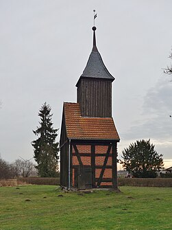
Tower of the former village church
|
|
Werder (also called Werder bei Neuruppin ) is a district of the municipality of Märkisch Linden in the Ostprignitz-Ruppin district in the state of Brandenburg . The head of the village is Günther Noack.
Geography and natural space
Werder is located on the Ruppiner Platte , in the center of the Ostprignitz-Ruppin district, about 65 km northwest of Berlin and 7 km west of the district town of Neuruppin, directly on the Autobahn 24 .
The village is located close to the eastern edge of a comparatively extensive, flat, undulating ground moraine island, which protrudes like a Werder from the surrounding meltwater valleys created at the time of the Frankfurt Stadium .
Shortly before Werder, on the road towards Walsleben, lies the Buchtenpfuhl and the Giernpfuhl can be found near the former estate park . The sheep washes are to the southwest of the village . The Steinfurtgraben essentially forms the northeast and eastern border of the village boundary. The southern border of the village is on Landwehrgraben .
In addition to the village, the Werder area mainly consists of fields, meadows and a few forests , such as the Kleiner Tannen , the Heidplan and a small forest between Gottberg and Werder.
Dabergotz , Kränzlin , Darritz , Walsleben , Paalzow and Gottberg are neighboring towns of the village.
history
The alleged namesake of the village is Arnoldus de Werder , who was mentioned in a document in 1362. Around 1490 Werder was part of the Ruppin rule, which was essentially imperial, under the rule of the Counts of Lindow-Ruppin .
Good Werder
Over the centuries the estate changed hands several times. The last owner, Baussen, was expropriated by the land reform in 1945 and the land was divided among farmers , landless people and displaced persons from the former eastern regions. They were each awarded 5 hectares. After the land reform in 1945, the Soviet soldiers worked on the property for a while. Since the building was too dilapidated, it was decided to demolish the building. The manor house was demolished in the winter of 1970/1971. The building was previously used as a kindergarten and nurses' station. The farm building of the estate was today's residential building No. 67. Next to it was the manor house, where the buildings of the volunteer fire brigade and the village community center are today .
Population development
- 1766: 153 inhabitants
- 1800: 232 inhabitants
- 1946: 641 inhabitants
- 1964: 356 inhabitants
- 1995: 262 inhabitants
- 2003: 344 inhabitants
- 2015: 327 inhabitants
Attractions
- Church tower: The half-timbered church was built in 1726. The nave had to be demolished in 1982 due to sponge infestation . In 2002 the church tower was renovated. While working in the ball below the spire, the craftsmen found old documents from 1929 with the year 1726. The history of the place from the Second World War is now hidden in the copper ball. The tower is equipped with two bells: a large one, which was made by Martin Heintz from Berlin in 1677, and a small one with a diameter of 44 centimeters. Church services have been held in the rectory since the 1960s.
- There is also a memorial for war victims in front of the church tower . It was built after the First World War . A renovation took place in 1992.
societies
- Fire brigade association "Friends of the Werder Fire Brigade" eV
- Women sports group
- Schützenverein Werder eV
- Heimatverein Werder eV
traffic
Werder is on Kreisstraße 6808, and there are also a few side streets in the village. Centrally located in the village, there is an ORP bus stop on both sides of the main road . Paved roads lead from Werder to Dabergotz, Walsleben, Kränzlin or Darritz and to Gottberg. There is a cycle path in the direction of Dabergotz. The federal highway 24 runs north of the village.
From 1902 to December 2006 Werder had a rail connection through the Neustadt – Neuruppin railway line , which was last served by the Prignitzer Eisenbahn GmbH in passenger traffic. The Werder train stop (b Neuruppin) was outside the village.
education
The “Sunshine” daycare center in the village has a capacity for 25 children. The facility is open Monday through Friday from 6:00 a.m. to 5:00 p.m. There are currently 3 educators working in the day-care center.
Web links
Individual evidence
- ↑ Codex diplomaticus Brandenburgensis . Fourth volume, pp. 293/294 from 1844.
- ↑ a b c d e Ruppiner Tageblatt. Wednesday, December 21, 2005, p. 18.
- ↑ Kreiskalender Ostprignitz-Ruppin 1996, p. 189
- ^ District calendar Ostprignitz-Ruppin 2004, p. 254
- ↑ amt-temnitz.de ( Memento of the original from July 11, 2016 in the Internet Archive ) Info: The archive link was inserted automatically and has not yet been checked. Please check the original and archive link according to the instructions and then remove this notice. (PDF).
- ↑ Ruppiner Kreisbahn on bahnstrecken.de.
- ↑ amt-temnitz.de
