West Dulwich
| West Dulwich | ||
|---|---|---|
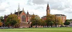
| Dulwich College | ||
| Coordinates | 51 ° 26 ′ N , 0 ° 5 ′ W | |
| OS National Grid | TQ333722 | |
|
|
||
| Residents | 14,119 | |
| language | English | |
| administration | ||
| Post town | LONDON | |
| ZIP code section | SE21 | |
| prefix | 020 | |
| Part of the country | England | |
| London Borough |
Southwark Lambeth |
|
| British Parliament | Dulwich and West Norwood | |
West Dulwich is a part of the London boroughs of Southwark and Lambeth . Together with East Dulwich and Dulwich Village , it forms the district of Dulwich . To the east is Dulwich East, to the south is bordered by West Norwood and to the west by Tulse Hill . In the north the district is bounded by Herne Hill .
history
The first written mention of the area around Dulwich comes from King Edgar I, who in 967 granted Earl Aelfheah, one of his thanes , a hamlet in the area. The name Dulwich has been pronounced in different ways over the years, such as Dilwihs , Dylways or Dullag and means something like "meadow where the dill grows". The land was owned by Harald II , among others, and after 1066 belonged to William the Conqueror . West Dulwich was formerly part of a floodplain known as Dulwich Common or The Croxteds . In the 17th century the area was drained by Edward Alleyn , the owner. With the construction of the London, Chatham and Dover Railway in 1863 and the opening of the Dulwich Railway Station that same year, West Dulwich was opened up to the people of London. Today 14,119 people live here.
politics
The district belongs to the constituency of Dulwich and West Norwood and has been represented in the House of Commons since 1997 by Tessa Jowell , who is a member of the Labor Party . In terms of local politics, it includes the electoral constituencies of College Ward, East Dulwich and Village Ward in the area of Southwark and Gipsy Hill Ward and Thurlow Park Ward in the area of Lambeth. Three of the nine local political representatives in the district belong to the Conservative Party , three more to the Liberal Democrats . The remaining two seats are held by members of the Labor Party.
sport and freetime
The Wanderers FC , a football club is based in West Dulwich. The club won the FA Cup five times at the end of the 19th century . There is also a club for lawn tennis and croquet . Dulwich Park, Dulwich Wood and many smaller parks are within walking distance.
Attractions
Founded by Edward Alleyn, Dulwich College is located in West Dulwich. It is one of four private schools in the vicinity. There are also four state primary schools.
Belair House (now Beauberry House ) is directly across from West Dulwich Railway Station . It was built for John Files in 1785 . It was privately owned until 1938 when it became part of Southwark Council. From the beginning of 1990 the house fell into disrepair until it was finally bought by a private investor in 1998 and converted into an upscale restaurant. The building has a large park that is open to the public. The lake in this park is the only part of the River Effra that does not flow underground.
The under monument protection standing All Saints Church is located in Rosendale Road. The building, built in neo -Gothic style between 1888 and 1897 to a design by the architect George Fellowes Prynne , was originally intended to serve as a cathedral for South London . However, the original design has been scaled down. On June 9, 2000, a fire broke out in the church building, severely damaging it. In April 2006 the church reopened after extensive renovations.
Kingswood House is a mansion in Victorian style , the original Queen Caroline belonged. Today it is publicly owned and is mainly used for conferences and weddings.
The Rosendale is one of the oldest pubs in West Dulwich, which was previously used as a coach house.
traffic
The district is connected to local public transport via the West Dulwich Railway Station . From there, Southeastern trains run to London Victoria Station in twelve minutes outside of peak hours . Trains also run to Blackfriars station during peak hours . Trains in the opposite direction go to Orpington . The place is also connected to the London Buses network by numerous bus routes . The closest London Underground station is Brixton Station . It is about five kilometers from the center of West Dulwich and is on the Victoria Line .
Famous residents
- Peter Cushing (1913–1994), actor
Individual evidence
- ↑ a b as of 2001
- ↑ Hibbert, Christopher; Booth, Pat; Weinreb, Ben: The London Encyclopedia . Macmillan, New York 1983, ISBN 0-333-32556-7 .
- ↑ Homepage of the association ( Memento of the original from November 5, 2013 in the Internet Archive ) Info: The archive link was automatically inserted and not yet checked. Please check the original and archive link according to the instructions and then remove this notice.
- ↑ Archived copy ( Memento of the original from April 16, 2008 in the Internet Archive ) Info: The archive link was inserted automatically and has not yet been checked. Please check the original and archive link according to the instructions and then remove this notice.


