West MacDonnell National Park
| West MacDonnell National Park | ||
|---|---|---|
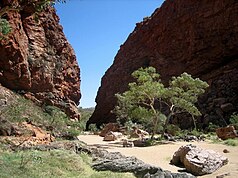
| Simpsons Gap | ||
|
|
||
| Location: | Northern Territory , Australia | |
| Specialty: | Mountain range with gorges | |
| Next city: | 30 kilometer (s) from Alice Springs | |
| Surface: | 2069 km² | |
| Founding: | 1992 | |
| View along the West MacDonnell Ranges from the Larapinta Trail, near Glen Helen. | ||
The West MacDonnell National Park (English West MacDonnell National Park ) covers a 2069 km² area in the mountain range of the MacDonnell Ranges in the Australian Northern Territory west of the city of Alice Springs .
It was founded in 1992 after the Northern Territory government bought 170,000 hectares of land from five cattle ranches that had been abandoned due to multiple avalanches.
From Alice Springs , the national park is connected by paved roads ( Larapinta Drive and Namatjira Drive ). From Uluṟu there is a slope that is only accessible with all-wheel drive.
The tourist attractions of this national park include:
- Larapinta Trail : Parts of the 223 km long long-distance hiking trail run through the national park.
- Rungutjirpa ( Simpson's Gap ): rocky canyon made of red sandstone; with a little luck, rock kangaroos and some rare bird species will show up in the early morning ; permanent water point at the end of the gorge. According to tradition, the Arrernte - Aborigines their ancestors were in this place Giants.
- Udepata ( Ellery Gorge ) in Ellery Creek Big Hole : Narrow, water-bearing serpentine gorge with river eucalyptus.
- Ormiston Gorge : Gorge with 300 m high walls made of two layers of quartz lying on top of each other.
- Redback Gorge
- Glen Helen Gorge


