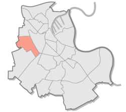
Westfeld (Neuss)
|
Westfeld District 15 of Neuss |
|
|---|---|
| Coordinates | 51 ° 11 '31 " N , 6 ° 38' 50" E |
| surface | 3.66 km² |
| Residents | 182 (Jun 30, 2014) |
| Population density | 50 inhabitants / km² |
| Post Code | 41464 |
| prefix | 02131 |
| Borough | Westfeld (15) |
| Transport links | |
| Highway |
|
| Bus line | 857T |
| Source: Timetable information from Stadtwerke Neuss | |
Westfeld is a purely agricultural district in the north-west of Neuss and, with only 124 inhabitants (as of June 30, 2014), is the district with the lowest population after the port area .
Geographical location
The district is located west of the stadium district , south of Morgensternsheide and north of Grefrath and Holzheim . In the west it borders on Büttgen . The Neuss city forest belongs to the immediate vicinity .
Web links
Commons : Westfeld (Neuss) - Collection of images, videos and audio files
- Website of the city of Neuss
- West field. (PDF; 4.3 MB) Proposal and recommendations from NEUSS-AGENDA 21 Urban Development Forum, Environment Forum to the City Council of Neuss. Neuss-Agenda 21 Urban Development Forum, September 28, 2005, accessed on January 5, 2015 .
Individual evidence
- ↑ District table - basic statistical data. City of Neuss, June 30, 2012, accessed January 5, 2015 .
