Hoists
|
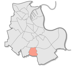
Hoisten district 25 of Neuss |
|
|---|---|
| Coordinates | 51 ° 8 '38 " N , 6 ° 42' 8" E |
| surface | 2.69 km² |
| Residents | 3152 (Jun. 30, 2014) |
| Population density | 1172 inhabitants / km² |
| Incorporation | Aug 1, 1929 |
| Post Code | 41469 |
| Borough | Hoists (25) |
| Transport links | |
| Bus lines | 844 SB53 878 |
| Source: Timetable information from Stadtwerke Neuss | |
Hoisten [ ˌhoːsten ] is a district of the city of Neuss in the Rhine district of Neuss .
location
Hoisten borders in the north on Weckhoven , in the east on the Hummelbach and Bettikum , in the south on the city of Grevenbroich , and in the west on the Gillbach and the places Speck and Wehl. Hoisten has an area of 2.69 km².
history
In the area of the Old Rhine on the Gohrer Berg between Hoisten and Gohr , individual pieces from the Stone Age and Bronze Age were found. The images can be found in the book Hoistadensis 2000 by Marianne Philipp. A coin of the Eastern Roman emperor Herakleios (610–641) from the years 612/613 was discovered in the school garden in Hoisten . In a document from the year 818, the "land of St. Peter" was transferred to the Werden monastery . Presumably this is the area of the later Catholic parish church of St. Peter. The name Hoisten is said to come from the name Hochstaden and was the seat of the Hoistadensis dynasty . In the 13th century the name Hovesteden was mentioned, which means something like farmstead . At that time the place belonged to Herr vom Helpenstein . In the 14th century Hoisten was owned by the Lords of Blankenheim and in 1415 came to the Dukes of Jülich and thus formed an enclave in Kurköln . The St. Peter Church was mentioned as early as 1300. During the Thirty Years' War the place was badly hit and people fled to the surrounding forests. In 1794 the French occupied Hoisten. The place now came to the canton of Elsen. In 1799, Hoisten had 375 inhabitants, 236 of whom were twelve years old and older. In 1815 Hoisten came to the Kingdom of Prussia and in 1816 to the mayor's office in Hülchrath , which was later renamed the Neukirchen community. On January 1, 1975, Hoisten was umgemeindet from Neukirchen to the city of Neuss.
Population development
- 2004: 3304 inhabitants. The population is older than usual in the city of Neuss: In the age group from 45 to 64 years, their share makes up 29.1%, while in the city of Neuss it makes up 26.4%. In the age group of 65 and over, the proportion in Hoisten is 20.7% and in the city of Neuss 18.2%.
- 2007: 3256 inhabitants
- 2008: 3243 inhabitants
- 2011: 3175 inhabitants
- 2014: 3152 inhabitants (as of June 30, 2014)
traffic
Bus routes 844, 878 and SB53 serve Hoisten. This provides a connection to Grevenbroich, the center of Neuss, the Norf S-Bahn station and other southern Neuss districts.
Infrastructure
- Industrial park with 50 companies in which around 300 employees work
- kindergarten
- Historic restaurant "Am Goldacker"
- Community elementary school Richard-Schirmann-Schule
- Volunteer fire brigade fire engine Hoisten
- Restaurant "Op de Eck"
- Wind energy plants Neuss-Hoisten
Personalities
The fantasy book author Wolfgang Hohlbein lives with his family in Hoisten.
Individual evidence
- ↑ See also www.hoistadensis.de ( Memento of the original from December 17, 2014 in the Internet Archive ) Info: The archive link was inserted automatically and has not yet been checked. Please check the original and archive link according to the instructions and then remove this notice.
- ↑ Martin Bünermann, Heinz Köstering: The communities and districts after the municipal territorial reform in North Rhine-Westphalia . Deutscher Gemeindeverlag, Cologne 1975, ISBN 3-555-30092-X .
- ↑ Population statistics for the city of Neuss (PDF; 286 kB)
- ^ District table for the city of Neuss
Web links
- District brochure on the website of the city of Neuss

