City center (Neuss)
|
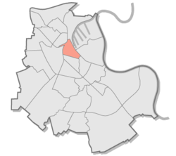
Inner city district 1 of Neuss |
|
|---|---|
| Coordinates | 51 ° 11 '55 " N , 6 ° 41' 29" E |
| surface | 1.49 km² |
| Residents | 11,956 (Jun. 30, 2017) |
| Population density | 8024 inhabitants / km² |
| Post Code | 41460 |
| prefix | 02131 |
| Borough | Downtown (1) |
| Transport links | |
| DB connection | Neuss main station |
| Light rail lines | U75 704 709 |
| Bus lines | 828 841 842 843 844 848 849 851 858 864 |
| Source: Timetable information from Stadtwerke Neuss | |
The city center of Neuss is a district of the district town of Neuss. With an area of 1.49 km² and 11,956 inhabitants (as of June 30, 2017), the inner city is one of the central districts.
Neighboring districts
The following districts border the city center district
| Furth | Barbaraviertel | Harbor area |
| Stadium district |

|
Hammfeld |
| Dreikönigenviertel | Augustine Quarter |
quarter
The downtown district comprises four quarters.
Marienviertel
The name of this quarter is given by the St. Marien church , which was completed in 1902. The Marienviertel is the link between Neuss main station and the city's pedestrian zone. By the beginning of 2015, the area between the train station and St. Mary's Church was redesigned. In recent years the district has been increasingly shaped by a mix of many different cultures.
Sebastianusviertel
The Sebastianusviertel lies between Marienviertel and Quirinusviertel. The Neumarkt, the Meererhof and the square at the Hamtor are the central points of contact in the district. The focus is on the St. Sebastianus Church.
Quirinus district
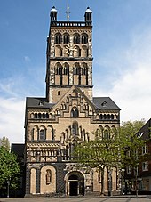
This quarter is the heart of Neuss city center and includes the actual old town. The Quirinus Minster , one of the most important late Romanesque churches on the Lower Rhine, is also the landmark of the city of Neuss. The town hall, the market and a large part of the pedestrian zone with many shops can be found here. In recent years there have been efforts to expand the inner city area to the adjoining port basin 1, the beginning of the port area.
Poor Clares Quarter
Culturally shaped by the Rheinisches Landestheater , the Rheinisches Schützenmuseum and the Clemens-Sels-Museum , the Klarissenviertel seamlessly connects to the Quirinusviertel. The only completely preserved gate of the Neuss city wall, the Obertor, is located directly at the Clemens Sels Museum . The Rhenish Rifle Museum in Neuss is housed in the Rottels House . In addition to the cultural focus, a large part of the district administration is also located here . Shops and shopping opportunities are rare in this area compared to other downtown areas.
Public facilities
Stadtbad Neuss
The Stadtbad was built in the late 1980s and modernized in the mid-2010s. In addition to a 50-meter pool with a wave system, the swimming pool has a grandstand for up to 100 people, a leisure pool with a waterfall, a puddle pool, a children's pool and a fitness room. The pool is used for swimming training by the inner city schools and the TG Neuss . In 2019, the pool is to be closed for two years and given a complete renovation.
Other facilities
- Edith Stein Family Forum
-
Romaneum
- Volkshochschule Neuss
- Music school of the city of Neuss
- Kulturforum Alte Post
- Rheinisches Landestheater Neuss
- City library of the city of Neuss
- House of Youth
education
Colleges
- Regional center of the Fernuniversität Hagen
- University of Neuss for International Economics
- Study location of the FOM University
Further training
- Quirinus-Gymnasium Neuss
- Marienberg High School
- Janusz Korczak Comprehensive School Neuss
Elementary schools
- Kreuzschule (municipal community elementary school)
- Münsterschule (Municipal Catholic Primary School)
- Martin Luther School (Municipal Protestant Primary School)
Churches
Catholic churches
Pastoral care area in Neuss-Mitte
- St. Mary
- Quirinus Minster
- St. Sebastianus
- Marienberg Chapel
Protestant churches
- Christ Church
Public transport
The city center is the central hub of Neuss local transport, which is operated by the Neuss municipal utility . Without exception, all Neuss bus routes go through the city center. In addition, there is a direct connection to local rail transport through Neuss main station . By the rail lines of Rheinbahn the district in addition to the rail Rhein-Ruhr connected. The low-floor tram 709 goes directly through the city center, so that all shops within the pedestrian zone can be easily reached.
Web links
- Ludger Baten: Downtown - where the quarters are still intact. Neuss-Grevenbroicher Zeitung , October 1, 2013, accessed on November 25, 2014 (report as part of the district series about Neuss city center).
Individual evidence
- ↑ District table - basic statistical data. City of Neuss, June 30, 2017, accessed on March 21, 2018 .
- ^ District map of the city of Neuss. City of Neuss, accessed on December 28, 2014 .
- ↑ Map of the quarters on the website of the Neuss Future Initiative (ZIN eV) ( Memento from December 16, 2014 in the Internet Archive )
- ↑ Theodor-Heuss-Platz should be ready in early January. Westdeutsche Zeitung , October 24, 2014, accessed on November 26, 2014 .
- ↑ Ute Böhm: Marienviertel is becoming more and more multicultural. Neuss-Grevenbroicher Zeitung , February 17, 2015, accessed on February 18, 2015 .
- ↑ City harbor Neuss - A city moves closer to the water. (PDF; 1.39 MB) (No longer available online.) Stadthafen Neuss Verwaltungsgesellschaft mbH, archived from the original on February 24, 2015 ; Retrieved November 26, 2014 .
- ↑ Website of the Stadtbad ( Memento from December 28, 2014 in the Internet Archive )
- ↑ Primary schools in Neuss. (PDF; 5.30 MB) Education Office for the Rhein-Kreis Neuss, accessed on November 27, 2014 .


