Windisch-Minihof
|
Windisch-Minihof ( village ) village cadastral Windisch Minihof |
||
|---|---|---|
|
|
||
| Basic data | ||
| Pole. District , state | Jennersdorf (JE), Burgenland | |
| Judicial district | Gussing | |
| Pole. local community | Minihof-Liebau | |
| Coordinates | 46 ° 53 '27 " N , 16 ° 5' 44" E | |
| height | 277 m above sea level A. | |
| Residents of the village | 434 (January 1, 2020) | |
| Building status | 187 (2001) | |
| Area d. KG | 7.95 km² | |
| Statistical identification | ||
| Locality code | 00099 | |
| Cadastral parish number | 31132 | |
| Counting district / district | Windisch-Minihof (10505 001) | |
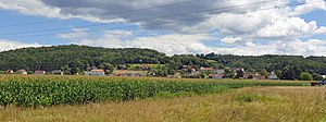
 View of Windisch-Minihof from the north-west |
||
| Source: STAT : index of places ; BEV : GEONAM ; GIS-Bgld | ||
Windisch-Minihof is a village and a cadastral community in the municipality of Minihof-Liebau .
The village with Angerform is located in the Doiberbachtal.
The place was first mentioned in documents in 1387.
- South of the branch chapel St. Johannes , three-sided courtyards are loosely built.
- There is a wayside cross in front of the church and a wayside cross on the Gamperlberg.
- On the main square there is a model of a thatched courtyard as a block construction.
- The Jost Mühle is located on the Doibersbach , the last water-powered mill in the Raab Nature Park.
- Views of Windisch-Minihof
literature
- DEHIO manual. The art monuments of Austria: Burgenland. Windisch Minihof. Bundesdenkmalamt (Ed.), Verlag Anton Schroll & Co, Vienna 1976, ISBN 3-7031-0401-5 , page 323.
Web links
Commons : Windisch-Minihof - Collection of images, videos and audio files


