
Tauka
|
Tauka ( village ) locality Tauka cadastral municipality |
|||
|---|---|---|---|
|
|||
| Basic data | |||
| Pole. District , state | Jennersdorf (JE), Burgenland | ||
| Judicial district | Gussing | ||
| Pole. local community | Minihof-Liebau | ||
| Coordinates | 46 ° 51 '48 " N , 16 ° 4' 29" E | ||
| height | 300 m above sea level A. | ||
| Residents of the village | 293 (January 1, 2020) | ||
| Building status | 117 (2001) | ||
| Area d. KG | 4.54 km² | ||
| Statistical identification | |||
| Locality code | 00098 | ||
| Cadastral parish number | 31128 | ||
| Counting district / district | Tauka (10505 002) | ||
 View from the west of the village of Tauka |
|||
| Source: STAT : index of places ; BEV : GEONAM ; GIS-Bgld | |||

Tauka ( Hungarian : Tóka) is a village and a cadastral municipality in the municipality of Minihof-Liebau .
The village is located on the Austrian side at the border triangle of Austria , Slovenia and Hungary . The border crossing at Tauka was regulated very differently due to the strong political changes in the 20th century.
- Views of Tauka

Village street

kindergarten
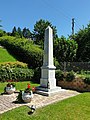
War memorial

graveyard
.jpg)


.jpg)
Personalities
- Verena Nusz (1949–1997), painter and graphic artist
Web links
Individual evidence
- ^ Tauka border triangle . Retrieved August 27, 2015.
- ↑ Nature park and market town of Minihof-Liebau . Retrieved August 27, 2015.
- ↑ Grenzstein am Dreiländereck, photo no. 80, in: Margit Pflagner , J. Marco (photos): Burgenland. 80 color pictures with explanations in German and English. Preface by the Governor of Burgenland Theodor Kery , English translation: Ursula Halama, Frick Verlag, Vienna 1970.
- ↑ austriasites.net ( page no longer available , search in web archives ) Info: The link was automatically marked as defective. Please check the link according to the instructions and then remove this notice. Tauka (postal code 8384): (Hungarian: Tóka): 15 photos of the place Tauka
- ↑ kloarichterin development of Zollwache in District Jennersdorf : of the terrible tragedies at the border until Gleichenberger agreement

Cadastral communities: Minihof-Liebau | Tauka | Windisch Minihof
Locations: Minihof-Liebau | Tauka | Windisch Minihof
Market place: Minihof-Liebau Villages: Tauka | Windisch Minihof Rotten: Bach • Gamperlberg • Grundberg • Judenberg • Kramerberg • furs Reck • Pete Reck • Schusterberg • Trench • Theresienberg • Thomas Berg • angle Scattered houses: Loasleiten • melt stretching • Zotterberg
Counting area: Minihof-Liebau | Windisch Minihof | Tauka