Wintzingerode (Leinefelde-Worbis)
|
Wintzingerode
City of Leinefelde-Worbis
|
|
|---|---|
| Coordinates: 51 ° 26 ′ 38 ″ N , 10 ° 20 ′ 2 ″ E | |
| Height : | 284 (280-315) m |
| Residents : | 643 (Feb 29, 2016) |
| Incorporation : | March 16, 2004 |
| Postal code : | 37339 |
| Area code : | 036074 |
|
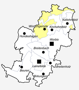
Location of Wintzingerode in Leinefelde-Worbis
|
|
|
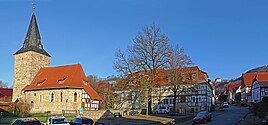
St. Katharina, Anger and Bodenstein Castle
|
|
Wintzingerode is a district of Leinefelde-Worbis in the Eichsfeld district in Thuringia .
location
Wintzingerode is located in the upper Hahletal on the southwestern edge of the Ohm Mountains , about three kilometers north-northwest of Worbis. The Bodenstein settlement immediately east of Bodenstein Castle also belongs to the place . Today the DRK-Bildungswerk Thuringia is located there. The place also includes extensive forest and pasture areas north of the two neighboring towns of Kaltohmfeld and Kirchohmfeld, which came to the village with the estate districts of Bodenstein and Adelsborn of the Counts and Barons of Wintzingerode .
history
In 1204 the place Wintzingerode is mentioned for the first time in a document in which the rights of the monastery Lippoldsberg to the tithe of some villages are sold to the monastery Pöhlde . The ancestors of the later counts and barons of Wintzingerode had their residence here. Bodenstein Castle is located above the village . The first mention of a church comes from the year 1389. In the 16th century the place, like their rule, adopted the Protestant faith. Around 1530 Wintzingerode was a desert village. By comparing the farmers from five villages with Hans von Wintzingerode in 1580, a resettlement was favored. In 1633 Heinrich von Wintzingerode set up a free school for the children of the feudal people.
In the American artillery bombardment on the evening of April 9, 1945, seven residents were killed, six of them women. On April 10th, the place was occupied without a fight. From the beginning of July 1945 Wintzingerode was also occupied by the Red Army and incorporated into the Soviet Zone .
Since March 16, 2004 the place belongs to the city of Leinefelde-Worbis.
Attractions
- St. Katharina (Wintzingerode)
- Bodenstein Castle
- Catherine Spring
Personalities
- Gottlieb Ernst August Mehmel (1761–1840), German philosopher
traffic
The Wintzingerode station was on the Untereichsfeldbahn , which has since been shut down and is overbuilt here by the B 247 around the town . The Unstrut-Hahle cycle path was set up on part of the track bed .
coat of arms
Blasonierung : "Split, front, rear, in green a silver links shaft pile divided , cited in Silver an obliquely right red Glefenspitze cleaved bottom of black and red, the front three silver beam , behind a left-turned-over (along the plate edge) rising golden lion."
Declaration of the coat of arms: The silver wavy bar in green is the Katharinenbach , which flows through the village, the division on the left primarily indicates the former rule. The red Glefenspitze (“halberd tip ”, incorrectly “fire hook” or “ grappling hook ”) in silver stands for the family of those from Wintzingerode , who significantly influenced the history of the place, for the noble family of those from Bodenstein , who can be traced back to Wintzingerode in the 13th century Owned goods and gave the Bodenstein Castle its name, the silver bars are in black and the lion in red.
Web links
- Website: http://www.wintzingerode.de/
Individual evidence
- ↑ Alois Schmidt: Documents of the Eichsfeldes part 1 , Magdeburg 1933, page 97
- ^ Eduard Fritze: The last days of the war in Eichsfeld . Rockstuhl Verlag, Bad Langensalza 2002. ISBN 3-936030-06-5 . Pp. 201-202
- ^ StBA: Changes in the municipalities in Germany, see 2004


