Wirmboden
| Wirmboden ( Alpe ) | ||
|---|---|---|
|
|
||
| Basic data | ||
| Pole. District , state | Bregenz (B), Vorarlberg | |
| Judicial district | Bregenz | |
| Pole. local community | Schnepfau | |
| Locality | Schnepfau | |
| Coordinates | 47 ° 20 ′ 32 ″ N , 9 ° 56 ′ 0 ″ E | |
| height | 925 m above sea level A. | |
| Post Code | 6882 Schnepfau | |
| prefix | + 43/05518 (Schnepfau) | |
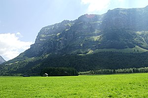
 Directly under the Kanisfluh (on the right half of the picture), the Vorsäß Wirmboden |
||
| Source: STAT : index of places ; BEV : GEONAM ; VoGIS | ||
Wirmboden is a low-lying alp (Voralpe / Maiensäß ) in the municipality of Schnepfau in Vorarlberg , Austria . It is used for livestock farming in spring and autumn.
Origin of name
The part of the name Wirm occurs in Vorarlberg only here in the Schnepfau community. According to legend, the Kanisfluh is said to have been built by the giant Wirm, who was so dissatisfied with his work that he threw himself to death from this mountain.
history
The settlement on the Wirmboden has been documented since the 17th century. It was used continuously as a pre-Alps and was not permanently inhabited.
Topography, geography, location and traffic
The cultivated part of the Wirmboden Vorsäß with the plot number 1271 lies between 845 m above sea level. A. and 1150 m above sea level. A. at the southern end of the municipality of Schnepfau. The buildings of the Vorsäß are at about 925 m above sea level. A. To the west, the Vorsäß is bounded by the Hoppenbach (Enge Vorsäß) and to the east by the Eschgraben (Bühlen Vorsäß). The length of this property is around 1250 m and it is around 500 m wide. The Vorsäß is about 1500 m as the crow flies from Schnepfau, about 23 km as the crow flies to Lake Constance and about 17 km to Dornbirn .
The mountain range Kanisfluh with the summit Hohe Stoss ( 1806 m above sea level ), Holenke ( 2044 m above sea level ), the Runde Kopf ( 2014 m above sea level ) and the Sonnenspitze ( 1965 m above sea level ) dominates this mountain pasture on the southern side and with its striking rock face also dominates the valley around Schnepfau. The topographical basis ( landslide moraine landscape ), on which the Wirmboden and Bühlen mountain passages rise , also originates from this mountain range .
As the owner of the basic plot in 1271 with a total area of 2,502,132 sqm (250.2132 hectares ) is farming community Vorsäßgenossenschaft Wirmboden registered in the land register.
There is only a non-public access road to Wirmboden and various hiking trails. The paths are not accessible in winter due to the risk of avalanches.
The spine ( Wirmasul or Wirmsul ) in the Kanisfluh massif is close to the Wirmbodens. This is about 60-70 m high on the mountain side and about 100-120 m on the valley side.
economy
The Vorsäß is largely used for agriculture. Accommodation with six beds is also available in summer.
Right next to the Vorsäß, next to the Hoppenbach, gravel is planned to be extracted in an open pit . Up to 800,000 m³ are to be extracted over the next 30 years. This leads to considerable resistance in the population of the Bregenzerwald and also in the communities of Schnepfau and Mellau. Due to the special nature of the area, it is planned to put it under nature protection in order to prevent such interference. The planned local protection area would cover around 100 hectares. In the west it would extend to the municipal boundary of Mellau, in a northerly direction to the Bregenzerach, in an easterly direction to an already approved gravel quarrying site in the Höpperne-Vorsäß or above the Wirmboden-Vorsäß and in a southerly direction to the Kanisfluhmassiv.
religion
After an avalanche destroyed the old chapel on the edge of the settlement on February 15, 2012, a new chapel in the middle of the settlement was inaugurated on August 7, 2016 (see main article: Wirmboden mountain chapel ).
Web links
Individual evidence
- ↑ Kanisfluh , haben.at, last accessed on December 31, 2017.
- ↑ Florian Aicher: "Wirmboden" in Vorarlberger Nachrichten, supplement "Leben und Wohnen" from December 23, 2017, p. 6, online .
- ^ Schnepfau land register.
- ↑ Hans Peter Jeschke, Peter Mandl: Klagenfurter Geographische Schriften, issue 28, Institute for Geography and Regional Research of the University of Klagenfurt, Klagenfurt 2012, p. 276.
- ↑ Dimensions according to the land register of the cadastral community 91015 Schnepfau, EZ 115, Bezau district court.
- ↑ Alban Glaser: Kanisfluh Nordwand, (Holenke, Hauptgipfel) , October 6, 2005, last accessed on December 31, 2017.
- ↑ Schnepfau wants nature reserve instead of gravel pit , orf.at from June 26, 2017, last accessed on December 31, 2017.
- ↑ Florian Aicher: "Wirmboden" in Vorarlberger Nachrichten, supplement "Leben und Wohnen" from December 23, 2017, p. 6.


