Wotje
| Wotje | ||
|---|---|---|
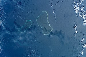
| NASA image of Wotje (center, left Erikub ) | ||
| Waters | Pacific Ocean | |
| archipelago | Marshall Islands | |
| Geographical location | 9 ° 27 ' N , 170 ° 1' E | |
|
|
||
| Number of islands | 75 | |
| Main island | Wotje | |
| Land area | 8.18 km² | |
| Lagoon area | 624 km² | |
| Residents | 859 (2011) | |
| Map of the Votje Atoll (1967) | ||
Wotje (German outdated: Rumanzoff Islands ) is an atoll of the Ratak chain of the Marshall Islands in the Pacific .
geography
The atoll has a land area of 8.18 km² with a lagoon area of 624 km². There are a total of four churches on Wotje: the Catholic, the Protestant, the Assembly of God and the Full Gospel. There are also four schools on the island: the Wodmej School, the Wotje Elementary School, the St. Thomas Elementary School run by Catholic sisters and the High School of the Islands of the North.
traffic
The island has an airfield ( IATA code : WTE) through which goods such as rice and sugar are flown in. There is also a ship bought by the island administration, the Northern Star , which is used by islanders for excursions.
history
Aircraft wrecks, the destroyed Japanese military airfield and other remnants of the Japanese occupation make the island a destination for those interested in World War II.
The islanders celebrate Freedom Day on June 9th each year, which is the celebration of the liberation from the Japanese.
Individual evidence
- ↑ German Colonial Lexicon. Edited by Heinrich Schnee. - Leipzig: Quelle & Meyer 1920. - 3 vols.
Web links
- Image and short description (Engl.) ( Memento of 23 December 2010 at the Internet Archive )
- Information about the military airfield
- Geographical information, map


