Erikub
| Erikub | ||
|---|---|---|
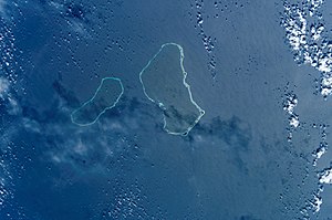
| NASA picture by Erikub (left, center Wotje ) | ||
| Waters | Pacific Ocean | |
| archipelago | Marshall Islands | |
| Geographical location | 9 ° 9 ′ N , 170 ° 0 ′ E | |
|
|
||
| Number of islands | 14th | |
| Main island | Erikub | |
| Land area | 1.53 km² | |
| Lagoon area | 230 km² | |
| Residents | uninhabited | |
| The southwest part of the atoll | ||
Erikub , also Ādkup or Ãdkup , is an uninhabited atoll in the Ratak chain of the Marshall Islands . The atoll has a land area of 1.53 km², which encloses a lagoon of 230 km². The atoll is only 8.6 km south of the neighboring atoll Wotje . The closest islands of the two atolls are 11 km apart. The highest point of the atoll is 9 m above sea level. Coconut palms grow on the island .
The largest of the 14 islands is Bokanaik (Bwokwanaik) with an area of 42 hectares , followed by Erikub (Ãdkup) with 29 hectares, both in the south of the atoll. Erikub is largely planted with coconut palms , while the other islands are mostly uncultivated. The atoll is visited by the inhabitants of Wotje for copra harvest .
The islands in clockwise order starting in the north:
- Jabonwar
- Aradojairen
- Aradojairik
- Guro
- Jeldoni
- Bogweido
- Bogella
- Jogan
- Bokku (Bok)
- Bogengoa (Bokan-koak)
- Bwokwanaik (Bokanaik)
- Erikub (Ãdkup)
- Loj
- Enego
Individual evidence
- ^ Edwin Horace Bryan: Guide to place names in the Trust Territory of the Pacific Islands: (the Marshall, Caroline and Mariana Islands) (Paperback). Honolulu: Pacific Scientific Information Center, 1971 (Original information: 0.162 sq. Mi. Or 0.112 sq.mi.).
- ^ F. Raymond Fosberg: A Review of the Natural History of the Marshall Islands. January 1990 (Atoll Research Bulletin No. 330) (PDF; 4.1 MB), page 91
Web links
- Image and short description (Engl.) ( Memento of 23 December 2010 at the Internet Archive )
- Geographical information


