
Majuro Atoll
| Majuro Atoll | ||
|---|---|---|
 |
||
| Waters | Pacific Ocean | |
| archipelago | Marshall Islands | |
| Geographical location | 7 ° 4 ′ N , 171 ° 16 ′ E | |
|
||
| Number of islands | 64 | |
| Main island | Darrit | |
| length | 40.3 km | |
| width | 11.1 km | |
| Land area | 9.71 km² | |
| Lagoon area | 295.05 km² | |
| total area | 383 km² | |
| Residents | 27,797 (2011) | |
 |
||


The Majuro Atoll ( Marshallese Mājro , formerly Arrowsmith ) is an atoll of the Marshall Islands . On it lies Majuro , the capital of the Pacific republic of the Marshall Islands.
geography
The atoll has 64 small motus (reef islands), almost a third of which are inhabited. 20 individual places or inhabited islands are identified. The Marshal capital Majuro encompasses the entire atoll. The government buildings and embassies are concentrated on the islands of Delap , Uliga and Darrit in the east. For statistical purposes this densely populated area is called Delap-Uliga-Darrit or Rita (name variant of Darrit). The land area of the atoll is 9.71 km², while the lagoon extends over 295.05 km².
The northern part of the atoll ring has larger gaps. In the northwest is the Enyagin Group with the main islands Rongrong and Jelte. In the northeast are the islands of the former Aeankan district west of Darrit .
Intensive agriculture is also practiced on the southern islands of the atoll, mainly taro , sweet potatoes and fruit are grown. On the small northern atoll islands there are isolated coconut plantations for copra production .
To the west is the Motu Laura .
Infrastructure
Municipal infrastructure
The Majuro water and wastewater company receives water from several collecting basins directly in the catchment area of the airport. In this way they provide 530 million liters of water per year, but this is only available to the population for 12 hours a day. In general, the Marshall Islands have to deal with frequent water shortages.
transport
The Marshall Islands Airport is located on the southern Motu Rairok , which is west of Delap .
population
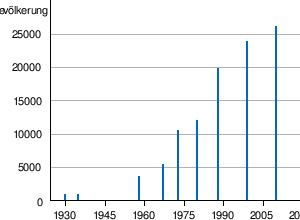
At the last census on June 1, 1999, the atoll had 23,676 inhabitants. By 2011, the population had only increased slightly to around 27,797.
Population development
At the time of German colonial rule, Majuro had 1,600 inhabitants (out of a total of 15,000 in the Marshall Islands). The population of the atoll has increased sharply since 1958:
| 1930 | 1958 | 1967 | 1973 | 1980 | 1988 | 1999 | 2011 | |
|---|---|---|---|---|---|---|---|---|
| 753 | 779 | 3,415 | 5,249 | 10,290 | 11,791 | 19,664 | 23,676 | 27,797 |
history

From 1885 to 1919, the Majuro Atoll, like the surrounding Marshall Islands, was part of the German South Sea holdings . The German colonial encyclopedia names the rich stock of coconut palms and breadfruit trees. After the First World War , the atoll was part of the Japanese South Seas mandate . On January 30, 1944, it was liberated from the Japanese by American troops.
Attractions
The Outrigger National Cup, the world's only outrigger canoe race, takes place in the Majuro lagoon .
Sports
The only stadium in the country, the Sports Stadium, stands on the atoll .
literature
- Names Of Islands Of Majuro Atoll . (List and map of 65 partly former islands in the Majuro Atoll; Textarchiv - Internet Archive )
Web links
- Picture and short description ( memento from December 23, 2010 in the Internet Archive )
- Photos from the Second World War (English)
- History, maps and pictures of the atoll
Individual evidence
- ↑ Population statistics ( memento of the original dated December 29, 2011 in the Internet Archive ) Info: The archive link was inserted automatically and has not yet been checked. Please check the original and archive link according to the instructions and then remove this notice.
- ↑ majuromok.tripod.com
- ↑ Peter Mellgard: Perishing Of Thirst In A Pacific Paradise in The World Post of December 28, 2015
- ↑ a b Statoids
- ^ Marshall Islands . In: Encyclopædia Britannica . 11th edition. tape 17 : Lord Chamberlain - Mecklenburg . London 1911, p. 773 (English, full text [ Wikisource ] - therein the atoll is called Majeru ).
- ↑ spc.int
- ^ ON: Majuro, in: Heinrich Schnee (Hrsg.): Deutsches Kolonial-Lexikon Volume II, Leipzig 1920, p. 480.
Ratak chain :
Ailuk |
Arno Atoll |
Aur |
Bikar |
Bokak |
Erikub |
Knox Atoll |
Likiep |
Majuro Atoll |
Maloelap |
Mili |
Toke |
Utirik |
Wotje
Islands not belonging to any atoll:
Jemo | Mejit
Ralik chain :
Ailinginae |
Ailinglaplap |
Bikini Atoll |
Ebon Atoll |
Eniwetok |
Jaluit |
Kwajalein |
Lae Atoll |
Namorik |
Namu |
Rongdrik |
Rongelap Atoll |
Ujae |
Ujelang |
Wotho
Islands not belonging to
any atoll: Jabwot |
Kili |
Lib
Claimed: Wake