
Wróblówka
| Wróblówka | |||
|---|---|---|---|

|
|
||
| Basic data | |||
| State : | Poland | ||
| Voivodeship : | Lesser Poland | ||
| Powiat : | Nowy Targ | ||
| Gmina : | Czarny Dunajec | ||
| Geographic location : | 49 ° 27 ' N , 19 ° 53' E | ||
| Residents : | 557 (2004) | ||
| Telephone code : | (+48) 18 | ||
| License plate : | KNT | ||

Wróblówka is a village in the municipality of Czarny Dunajec in the Powiat Nowotarski of the Lesser Poland Voivodeship in Poland in the Podhale region . The village is on Voivodeship Road 958 . The village is located in the Kotlina Nowotarska valley about 24 km northwest of Zakopane and 10 km west of Nowy Targ . The mountain river Czarny Dunajec flows through the village .
Attractions
Wróblówka was created in 1601. The place name can be translated as Spatzendorf . There is a modern church in the village.
tourism
It goes into Wróblówka quieter than in the neighboring resorts of Zakopane and Kościelisko. The tourist infrastructure is being expanded.
gallery
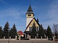
church

church
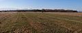
Western Tatras
.jpg)
.jpg)
.jpg)
Web links
panorama
.jpg)
Chochołów | Ciche | Czarny Dunajec | Czerwienne | Dział | Koniówka | Odrowąż | Piekielnik | Pieniążkowice | Podczerwone | Podszkle | Ratułów | Stare Bystre | Wróblówka | Załuczne