
Czerwienne
| Czerwienne | |||
|---|---|---|---|

|
|
||
| Basic data | |||
| State : | Poland | ||
| Voivodeship : | Lesser Poland | ||
| Powiat : | Nowy Targ | ||
| Gmina : | Czarny Dunajec | ||
| Geographic location : | 49 ° 22 ' N , 19 ° 56' E | ||
| Residents : | 1515 (2004) | ||
| Telephone code : | (+48) 18 | ||
| License plate : | KNT | ||

Czerwienne is a village in the municipality of Czarny Dunajec in the powiat Nowotarski of the Lesser Poland Voivodeship in Poland in the Podhale region . The village is located in the Pogórze Gubałowskie mountain range about 10 km north of Zakopane and 10 km south of Nowy Targ .
Attractions
The place name can be translated as red . Until 1965 the place was called Międzyczerwienne , which can be translated as intermediate red . There is a modern church of Mary of Czestochowa in the village .
tourism
Things are quieter in Czerwienne than in the neighboring ski resorts of Zakopane or Kościelisko. The tourist infrastructure is being expanded.
Winter sports
There are several smaller lifts in the village.
gallery

Marienkirche
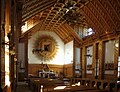
Church interior
panorama
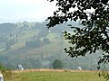
panorama

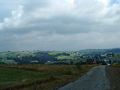
panorama

Western Tatras


Web links
Chochołów | Ciche | Czarny Dunajec | Czerwienne | Dział | Koniówka | Odrowąż | Piekielnik | Pieniążkowice | Podczerwone | Podszkle | Ratułów | Stare Bystre | Wróblówka | Załuczne