
Podczerwone
| Podczerwone | |||
|---|---|---|---|

|
|
||
| Basic data | |||
| State : | Poland | ||
| Voivodeship : | Lesser Poland | ||
| Powiat : | Nowy Targ | ||
| Gmina : | Czarny Dunajec | ||
| Geographic location : | 49 ° 24 ' N , 19 ° 50' E | ||
| Residents : | 700 (2004) | ||
| Telephone code : | (+48) 18 | ||
| License plate : | KNT | ||

Podczerwone is a village in the municipality of Czarny Dunajec in the powiat Nowotarski of the Lesser Poland Voivodeship in Poland in the Podhale region . The village is on Voivodeship Road 958 . The village lies between the mountain range Pogórze Gubałowskie and the valley basin Kotlina Nowotarska about fifteen kilometers northwest of Zakopane and two kilometers south of Czarny Dunajec. The mountain river Czarny Dunajec flows through the village . Until 1981, the station was the end point of the line from Zakopane , which continued into Czechoslovakia until 1939, served by passenger traffic. Today a bike path runs along the dismantled tracks.
Attractions
Podczerwone was created in 1605. The place name can be translated as Unterrot . There is a modern St. Mary's Church in the village. On November 29, 1943, German troops pacified the place because resistance fighters were hiding in it.
tourism
Things are quieter in Podczerwone than in the neighboring ski resorts of Zakopane or Kościelisko. The tourist infrastructure is being expanded.
gallery

Marienkirche
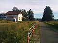
Former train station, new bike path

Connecting road


Web links
Individual proof
- ^ Ryszard Stankiewicz and Marcin Stiasny: Atlas Linii Kolejowych Polski 2014 . Eurosprinter, Rybnik 2014, ISBN 978-83-63652-12-8
Chochołów | Ciche | Czarny Dunajec | Czerwienne | Dział | Koniówka | Odrowąż | Piekielnik | Pieniążkowice | Podczerwone | Podszkle | Ratułów | Stare Bystre | Wróblówka | Załuczne