
Second Schafalpenkopf
| Second Schafalpenkopf | ||
|---|---|---|
 Second and first Schafalpenkopf |
||
| height | 2302 m above sea level NHN | |
| location |
Bavaria , Germany / Vorarlberg , Austria |
|
| Mountains | Southeastern Walsertal Mountains , Allgäu Alps | |
| Dominance | 0.6 km → Third Schafalpenkopf | |
| Notch height | 122 m ↓ notch to the third Schafalpenkopf | |
| Coordinates | 47 ° 18 '23 " N , 10 ° 12' 37" E | |
|
||
| rock | Main dolomite | |
| Normal way | Mindelheim via ferrata | |

The Second Schafalpenkopf (also Mittlerer Schafalpenkopf ) is a 2302 meter high mountain in the Allgäu Alps . It is part of the Schafalpenköpfe and the Mindelheim via ferrata .
Location and surroundings
The border between Germany and Austria runs over the summit of the Second Schafalpenkopf . Thus it is distributed over the federal states of Bavaria and Vorarlberg . On the Bavarian side it belongs to the administrative area of the district of Oberallgäu and Oberstdorf , on Austrian territory to the district of Bregenz and the municipality of Mittelberg .
To the northeast, the Second Schafalpenkopf is followed by the Third Schafalpenkopf (2320 m), from which it is separated by a gap at 2180 meters. It is the reference point for the 122 meter high notch of the Second Schafalpenkopf. The dominance of the Second Schafalpenkopf is 600 meters, so it extends to the Third Schafalpenkopf. The Rappenalptal is located in the south of the Second Schafalpenkopf . In the southwest, the Second Schafalpenkopf goes over to the First Schafalpenkopf (2272 m). In the northwest of the mountain is the Wildental , which leads into the Kleinwalsertal .
geology
The Second Schafalpenkopf is made of main dolomite .
Origin of name
The origin of the name of the Sheep Alpine Heads can be traced under Sheep Alpine Heads.
Alpinism
bases
The Fiderepasshütte and the Mindelheimer Hütte (2013 m) are the base points for tours on the Second Schafalpenkopf . In addition, access from Mittelberg through Wildental and from the mountain station of the Kanzelwandbahn is possible.
Routes
The Mindelheim via ferrata is the normal route for the Second Schafalpenkopf . This medium-difficulty via ferrata (C) crosses the mountain from northeast to southwest, from the third to the first Schafalpenkopf. Wire rope insurances and iron clamps help the mountaineer.
The routes from the time before the via ferrata was built hardly play a role today. The former normal route had difficulty I , in a more stringent, direct variant even III. It led through the south-western Kar Große Wanne to the summit. A route through the east face (level of difficulty V) was taken in 1920 by the climber Zitzelsberger and his companions.
photos
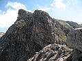
From the transition to the First Schafalpenkopf
From the Walser Hammerspitze

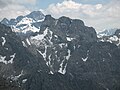
From the Third Schafalpenkopf

Via ferrata passage


Web links
Individual evidence
- ↑ Compass hiking, bike and ski tour map: Sheet 03 - Oberstdorf, Kleinwalsertal (1: 25,000). Innsbruck 2009, ISBN 978-3-85491-231-6 .
- ↑ Federal Office for Metrology and Surveying Austria: Austrian Map online . Retrieved August 14, 2010.
- ↑ http://geoportal.bayern.de:80/bayernatlas/?search=&X=5421649.25&Y=4459462.00&zoom=5&lang=de (link not available)
- ↑ Ernst Zettler, Heinz Groth: Alpine Club Guide - Allgäu Alps . 12th, completely revised edition. Bergverlag Rudolf Rother, Munich 1985, ISBN 3-7633-1111-4 (p. 491).
- ↑ Dieter Seibert: Alpine Club Guide alpine - Allgäu Alps and Ammergau Alps . 17th edition. Bergverlag Rother, Munich 2008, ISBN 978-3-7633-1126-2 (p. 187).
- ↑ Ernst Zettler, Heinz Groth: Alpine Club Guide - Allgäu Alps . 12th, completely revised edition. Bergverlag Rudolf Rother, Munich 1985, ISBN 3-7633-1111-4 (p. 492f).