
Tovariševo: Difference between revisions
m link case fix (via WP:JWB) |
|||
| (33 intermediate revisions by 18 users not shown) | |||
| Line 2: | Line 2: | ||
|official_name = Tovariševo |
|official_name = Tovariševo |
||
|other_name = |
|other_name = |
||
|native_name =Товаришево |
|native_name = {{native name|sr-Cyrl|Товаришево|italics=off}} |
||
|nickname = |
|nickname = |
||
|settlement_type = Village |
|settlement_type = [[List of populated places in Serbia|Village]] ([[village#Slavic countries|Selo]]) |
||
|motto = |
|motto = |
||
|image_skyline = Главна улица и центар села.jpg |
|image_skyline = Главна улица и центар села.jpg |
||
| Line 11: | Line 11: | ||
|image_flag = |
|image_flag = |
||
|flag_size = |
|flag_size = |
||
|image_seal = |
|image_seal = Tovarisevo - Grb.png |
||
|seal_size = |
|seal_size = 100 |
||
|image_map =Backa palanka mun.png |
|image_map =Backa palanka mun.png |
||
|mapsize = |
|mapsize = |
||
|map_caption =Map of the Bačka Palanka municipality, showing the location of Tovariševo |
|map_caption =Map of the Bačka Palanka municipality, showing the location of Tovariševo |
||
|pushpin_map = Serbia |
|pushpin_map = Serbia Vojvodina#Serbia#Europe |
||
|pushpin_label_position =bottom |
|pushpin_label_position =bottom |
||
|pushpin_mapsize= |
|pushpin_mapsize= |
||
|pushpin_map_caption = |
|pushpin_map_caption = |
||
|subdivision_type = Country |
| subdivision_type = [[List of sovereign states|Country]] |
||
|subdivision_name ={{flag|Serbia}} |
| subdivision_name = {{flag|Serbia}} |
||
|subdivision_type1 = [[Administrative divisions of Serbia|Province]] |
| subdivision_type1 = [[Administrative divisions of Serbia|Province]] |
||
|subdivision_name1 = {{flag|Vojvodina}} |
| subdivision_name1 = {{flag|Vojvodina}} |
||
|subdivision_type2 = [[ |
| subdivision_type2 = [[List of regions of Serbia|Region]] |
||
|subdivision_name2 = |
| subdivision_name2 = [[Bačka]] ([[Podunavlje]]) |
||
|subdivision_type3 = [[ |
| subdivision_type3 = [[Districts of Serbia|District]] |
||
|subdivision_name3 = |
| subdivision_name3 = [[South Bačka District|South Bačka]] |
||
| subdivision_type4 = [[Municipalities and cities of Serbia|Municipality]] |
|||
| subdivision_name4 = [[Bačka Palanka]] |
|||
|government_footnotes = |
|government_footnotes = |
||
|government_type = |
|government_type = |
||
| Line 39: | Line 41: | ||
|area_total_km2 = |
|area_total_km2 = |
||
|area_land_km2 = |
|area_land_km2 = |
||
|population_as_of = |
|population_as_of =2011 |
||
|population_footnotes = |
|population_footnotes = |
||
|population_note = |
|population_note = |
||
|population_total = |
|population_total = 2,657 |
||
|population_density_km2 = |
|population_density_km2 = |
||
|timezone =[[Central European Time|CET]] |
|timezone =[[Central European Time|CET]] |
||
| Line 48: | Line 50: | ||
|timezone_DST = [[Central European Summer Time|CEST]] |
|timezone_DST = [[Central European Summer Time|CEST]] |
||
|utc_offset_DST = +2 |
|utc_offset_DST = +2 |
||
|coordinates = {{coord|45|21|N|19|19|E|display=inline}} |
|||
|latd= 45|latm= 21|lats= |latNS= N |
|||
|longd= 19|longm= 19|longs= |longEW= E |
|||
|elevation_footnotes = |
|elevation_footnotes = |
||
|elevation_m = |
|elevation_m = |
||
| Line 61: | Line 62: | ||
|footnotes = |
|footnotes = |
||
}} |
}} |
||
[[File:Зграда Месне заједнице.jpg|right|thumb|250px|Local community office]] |
[[File:Зграда Месне заједнице.jpg|right|thumb|250px|Local community office]] |
||
'''Tovariševo''' ({{Lang-sr-Cyrl|Товаришево}}) is a village in [[Serbia]], in the Autonomous Province of [[Vojvodina]]. The village has a [[Serb]] ethnic majority and its population numbering 3,102 people (2002 census). |
'''Tovariševo''' ({{Lang-sr-Cyrl|Товаришево}}) is a village in [[Serbia]], in the Autonomous Province of [[Vojvodina]]. The village has a [[Serb]] ethnic majority and its population numbering 3,102 people (2002 census). |
||
| Line 73: | Line 75: | ||
== History == |
== History == |
||
Tovariševo is one of the old [[Serbs|Serb]] communities of [[Vojvodina]], first mentioned in 1543, during [[Ottoman Empire|Ottoman]] administration. It administratively was part of the Ottoman [[Sanjak of Segedin]]. In the end of the 17th century, the village was abandoned, but was repopulated in the beginning of the 18th century, during [[Habsburg |
Tovariševo is one of the old [[Serbs|Serb]] communities of [[Vojvodina]], first mentioned in 1543, during [[Ottoman Empire|Ottoman]] administration. It administratively was part of the Ottoman [[Sanjak of Segedin]]. In the end of the 17th century, the village was abandoned, but was repopulated in the beginning of the 18th century, during [[Habsburg monarchy|Habsburg]] administration. A description from the end of the 18th century (by [[András Vályi]]) states that ''"Tovarisova is a [[Raci (ethnonym)|Rac]]'' ([[Serbs|Serb]]) ''village in [[Bács-Bodrog County|Bács county]]. The landowner is the Royal Hungarian Chamber and the population follows the old faith'' (i.e. [[Serbian Orthodoxy|Orthodox]]). ''The black soil gives wheat, barley and oats, the village has an oak forest and a bad vineyard; it hasn't any water, but after the long autumn rains the soil became sodden; it lacks reed but it has silk-beetles. The nearest market-town is Újvidék ''([[Novi Sad]])'', where people can earn money from the sale of cattle."'' |
||
Until 1848, the village was part of the [[Bács-Bodrog County|Batsch-Bodrog County]] within the Habsburg [[Kingdom of Hungary]]. In 1848-1849 it was part of autonomous [[Serbian Vojvodina]], while from 1849 to 1860, it was part of the [[Voivodeship of Serbia and Banat of Temeschwar]], which was a separate Habsburg crownland. After abolishment of the voivodeship, in 1860, the village was again included into [[Bács-Bodrog County|Batsch-Bodrog County]]. |
Until 1848, the village was part of the [[Bács-Bodrog County|Batsch-Bodrog County]] within the Habsburg [[Kingdom of Hungary]]. In 1848-1849 it was part of autonomous [[Serbian Vojvodina]], while from 1849 to 1860, it was part of the [[Voivodeship of Serbia and Banat of Temeschwar]], which was a separate Habsburg crownland. After abolishment of the voivodeship, in 1860, the village was again included into [[Bács-Bodrog County|Batsch-Bodrog County]]. |
||
| Line 79: | Line 81: | ||
In 1787 population of the village numbered 1,490 inhabitants, while until the middle of the 19th century number of inhabitants was enlarged to 2,945. After 1843, a [[German people|German]] minority settled in the village next to the [[Serbs]], and they built a big [[Roman Catholic]] church dedicated to [[Saint Charles Borromeo]] in 1882. The population of Tovariševo was 3,439 (2,281 Serbs and 844 Germans) in 1880. |
In 1787 population of the village numbered 1,490 inhabitants, while until the middle of the 19th century number of inhabitants was enlarged to 2,945. After 1843, a [[German people|German]] minority settled in the village next to the [[Serbs]], and they built a big [[Roman Catholic]] church dedicated to [[Saint Charles Borromeo]] in 1882. The population of Tovariševo was 3,439 (2,281 Serbs and 844 Germans) in 1880. |
||
Since 1918, the village is part of the [[Kingdom of Serbs, Croats and Slovenes]] (renamed to [[Yugoslavia]] in 1929). In 1921, population of the village was 3,875, mostly Serb, while 850 inhabitants were Germans. From 1918 to 1922, the village was part of [[Novi Sad]] county, from 1922 to 1929 part of [[Bačka]] Oblast, and from 1929 to 1941 part of [[Danube Banovina]]. During the [[World War II|Second World War]], from 1941 to 1944, the village was under [[Axis Powers|Axis]] occupation and was attached to [[ |
Since 1918, the village is part of the [[Kingdom of Serbs, Croats and Slovenes]] (renamed to [[Yugoslavia]] in 1929). In 1921, population of the village was 3,875, mostly Serb, while 850 inhabitants were Germans. From 1918 to 1922, the village was part of [[Novi Sad]] county, from 1922 to 1929 part of [[Bačka]] Oblast, and from 1929 to 1941 part of [[Danube Banovina]]. During the [[World War II|Second World War]], from 1941 to 1944, the village was under [[Axis Powers|Axis]] occupation and was attached to [[Miklós Horthy|Horthy's]] [[Hungary during World War II|Hungary]]. |
||
In 1944, [[Soviet Union|Soviet]] [[Red Army]] and [[Yugoslav partisans]] expelled Axis troops from the region and village became part of the new [[SFRY|socialist Yugoslavia]]. Local German population mostly fled from the area together with defeated [[German |
In 1944, [[Soviet Union|Soviet]] [[Red Army]] and [[Yugoslav partisans]] expelled Axis troops from the region and village became part of the new [[SFRY|socialist Yugoslavia]]. Local German population mostly fled from the area together with defeated [[German Army (Wehrmacht)|German Army]]. Since 1944, the village is part of the autonomous province of [[Vojvodina]], which in 1945 was included into [[People's Republic of Serbia]] within [[Yugoslavia]]. |
||
==Demographics== |
==Demographics== |
||
| Line 92: | Line 94: | ||
*1981: 3,297 |
*1981: 3,297 |
||
*1991: 3,043 |
*1991: 3,043 |
||
*2002: 3,102 |
|||
*2011: 2,657 |
|||
== Sights == |
== Sights == |
||
In the middle of the village stands the baroque Serb-Orthodox Church, dedicated to Saint Gregory the Theologian (Bogoslov) and the Roman Catholic Church. The |
In the middle of the village stands the baroque Serb-Orthodox Church, dedicated to Saint Gregory the Theologian (Bogoslov) and the Roman Catholic Church. The latter is almost derelict because today it has only a weak Croatian and Hungarian congregation. |
||
==Gallery== |
|||
<gallery> |
<gallery> |
||
File:Сеча Бадњака-2009-1.jpg|Serb Christmas costumes |
File:Сеча Бадњака-2009-1.jpg|Serb Christmas costumes |
||
File:Спомен обележје борцима и настрадалим у Другом светском рату-2.jpg|WW2 memorial dedicated to fallen partisan fighters and victims of Axis occupation |
File:Спомен обележје борцима и настрадалим у Другом светском рату-2.jpg|WW2 memorial dedicated to fallen partisan fighters and victims of Axis occupation |
||
File:Tovariševo,_Catholic_Church.jpg|The Saint Charles Bormeian Catholic Church |
File:Tovariševo,_Catholic_Church.jpg|The Saint Charles Bormeian Catholic Church |
||
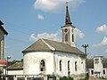
File:Steeple_of_the_Roman_Catholic_Church,_Tovariševo,_Vojvodina,_Serbia_-_20060602.jpg|The steeple of the Catholic church |
|||
</gallery> |
</gallery> |
||
| Line 111: | Line 117: | ||
==External links== |
==External links== |
||
*[http://dimitrije78.webs.io Welcome to Tovariševo] |
*[https://web.archive.org/web/20070927062039/http://dimitrije78.webs.io/ Welcome to Tovariševo] |
||
*[http://tovarisevo.mysite.com Zvanična prezentacija Tovariševa] |
*[http://tovarisevo.mysite.com Zvanična prezentacija Tovariševa] |
||
*[http://www.fkvojvodina.bap.rs Internet prezentacija FK Vojvodina Tovariševa] |
*[http://www.fkvojvodina.bap.rs Internet prezentacija FK Vojvodina Tovariševa] |
||
| Line 118: | Line 124: | ||
{{South Bačka District}} |
{{South Bačka District}} |
||
{{ |
{{Coord|45|21|N|19|19|E|region:RS_type:city|display=title}} |
||
{{ |
{{Commons category|Tovariševo}} |
||
{{Authority control}} |
|||
{{DEFAULTSORT:Tovarisevo}} |
{{DEFAULTSORT:Tovarisevo}} |
||
[[Category:Bačka Palanka]] |
[[Category:Bačka Palanka]] |
||
[[Category:Places in Bačka]] |
[[Category:Places in Bačka]] |
||
[[Category:Populated places in Vojvodina]] |
|||
[[Category:South Bačka District]] |
[[Category:South Bačka District]] |
||
[[fr:Tovariševo]] |
|||
[[hr:Tovariševo]] |
|||
[[it:Tovariševo]] |
|||
[[hu:Bácstóváros]] |
|||
[[sl:Tovariševo]] |
|||
[[sr:Товаришево]] |
|||
[[sh:Tovariševo]] |
|||
Latest revision as of 06:27, 5 April 2022
Tovariševo
Товаришево (Serbian) | |
|---|---|
 Main street and village center | |
 Seal | |
 Map of the Bačka Palanka municipality, showing the location of Tovariševo | |
 Tovariševo  Tovariševo  Tovariševo | |
| Coordinates: 45°21′N 19°19′E / 45.350°N 19.317°E | |
| Country | |
| Province | |
| Region | Bačka (Podunavlje) |
| District | South Bačka |
| Municipality | Bačka Palanka |
| Population (2011) | |
| • Total | 2,657 |
| Time zone | UTC+1 (CET) |
| • Summer (DST) | UTC+2 (CEST) |

Tovariševo (Serbian Cyrillic: Товаришево) is a village in Serbia, in the Autonomous Province of Vojvodina. The village has a Serb ethnic majority and its population numbering 3,102 people (2002 census).
Name[edit]
In Serbian, the village is known as Tovariševo or Товаришево, in German as Towarisch, in Hungarian as Bácstóváros (or former Tovarisova), and in Croatian as Tovariševo.
Geography[edit]
Tovariševo is located in the South Bačka District. Administratively it belongs to the municipality of Bačka Palanka.
History[edit]
Tovariševo is one of the old Serb communities of Vojvodina, first mentioned in 1543, during Ottoman administration. It administratively was part of the Ottoman Sanjak of Segedin. In the end of the 17th century, the village was abandoned, but was repopulated in the beginning of the 18th century, during Habsburg administration. A description from the end of the 18th century (by András Vályi) states that "Tovarisova is a Rac (Serb) village in Bács county. The landowner is the Royal Hungarian Chamber and the population follows the old faith (i.e. Orthodox). The black soil gives wheat, barley and oats, the village has an oak forest and a bad vineyard; it hasn't any water, but after the long autumn rains the soil became sodden; it lacks reed but it has silk-beetles. The nearest market-town is Újvidék (Novi Sad), where people can earn money from the sale of cattle."
Until 1848, the village was part of the Batsch-Bodrog County within the Habsburg Kingdom of Hungary. In 1848-1849 it was part of autonomous Serbian Vojvodina, while from 1849 to 1860, it was part of the Voivodeship of Serbia and Banat of Temeschwar, which was a separate Habsburg crownland. After abolishment of the voivodeship, in 1860, the village was again included into Batsch-Bodrog County.
In 1787 population of the village numbered 1,490 inhabitants, while until the middle of the 19th century number of inhabitants was enlarged to 2,945. After 1843, a German minority settled in the village next to the Serbs, and they built a big Roman Catholic church dedicated to Saint Charles Borromeo in 1882. The population of Tovariševo was 3,439 (2,281 Serbs and 844 Germans) in 1880.
Since 1918, the village is part of the Kingdom of Serbs, Croats and Slovenes (renamed to Yugoslavia in 1929). In 1921, population of the village was 3,875, mostly Serb, while 850 inhabitants were Germans. From 1918 to 1922, the village was part of Novi Sad county, from 1922 to 1929 part of Bačka Oblast, and from 1929 to 1941 part of Danube Banovina. During the Second World War, from 1941 to 1944, the village was under Axis occupation and was attached to Horthy's Hungary.
In 1944, Soviet Red Army and Yugoslav partisans expelled Axis troops from the region and village became part of the new socialist Yugoslavia. Local German population mostly fled from the area together with defeated German Army. Since 1944, the village is part of the autonomous province of Vojvodina, which in 1945 was included into People's Republic of Serbia within Yugoslavia.
Demographics[edit]
In 2002 the population of the village numbered 3,102 people, including 2,583 Serbs, 278 Roma, and others.
Historical population[edit]
- 1961: 3,581
- 1971: 3,381
- 1981: 3,297
- 1991: 3,043
- 2002: 3,102
- 2011: 2,657
Sights[edit]
In the middle of the village stands the baroque Serb-Orthodox Church, dedicated to Saint Gregory the Theologian (Bogoslov) and the Roman Catholic Church. The latter is almost derelict because today it has only a weak Croatian and Hungarian congregation.
Gallery[edit]
-
 Serb Christmas costumes
 -
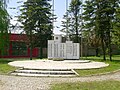 WW2 memorial dedicated to fallen partisan fighters and victims of Axis occupation
 -
 The Saint Charles Bormeian Catholic Church
 -
 The steeple of the Catholic church


See also[edit]
References[edit]
- Slobodan Ćurčić, Broj stanovnika Vojvodine, Novi Sad, 1996.
External links[edit]
- Welcome to Tovariševo
- Zvanična prezentacija Tovariševa
- Internet prezentacija FK Vojvodina Tovariševa
- Tovariševo - Mapa opštine Bačka Palanka
45°21′N 19°19′E / 45.350°N 19.317°E