Čelčice: Difference between revisions
Content deleted Content added
population, infobox |
population |
||
| (One intermediate revision by the same user not shown) | |||
| Line 1: | Line 1: | ||
{{Infobox settlement |
{{Infobox settlement |
||
| name = Čelčice |
| name = Čelčice |
||
| native_name = |
|||
| other_name = |
| other_name = |
||
| settlement_type = [[Obec|Municipality]] |
| settlement_type = [[Obec|Municipality]] |
||
<!-- images |
<!-- images --> |
||
| image_skyline = Čelčice, OÚ.jpg |
| image_skyline = Čelčice, OÚ.jpg |
||
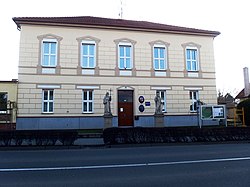
| image_caption = Municipal office |
| image_caption = Municipal office |
||
| image_flag = Čelčice flag.jpg |
| image_flag = Čelčice flag.jpg |
||
| image_shield = Čelčice PV CZ CoA.jpg |
| image_shield = Čelčice PV CZ CoA.jpg |
||
| etymology = |
|||
<!-- location --> |
<!-- location --> |
||
| subdivision_type = Country |
| subdivision_type = Country |
||
| Line 38: | Line 36: | ||
| elevation_m = 209 |
| elevation_m = 209 |
||
<!-- population --> |
<!-- population --> |
||
| population_as_of = |
| population_as_of = 2023-01-01 |
||
| population_footnotes = <ref>{{cite web |title=Population of Municipalities – 1 January |
| population_footnotes = <ref>{{cite web |title=Population of Municipalities – 1 January 2023|url=https://www.czso.cz/csu/czso/population-of-municipalities-1-january-2023|publisher=[[Czech Statistical Office]]|date=2023-05-23}}</ref> |
||
| population_total = |
| population_total = 504 |
||
| population_density_km2 = auto |
| population_density_km2 = auto |
||
<!-- time zone(s) --> |
<!-- time zone(s) --> |
||
| Line 64: | Line 62: | ||
{{commons category|Čelčice}} |
{{commons category|Čelčice}} |
||
{{Prostějov District}} |
{{Prostějov District}} |
||
Revision as of 13:08, 19 June 2023
Čelčice | |
|---|---|
 Municipal office | |
| Coordinates: 49°24′44″N 17°11′37″E / 49.41222°N 17.19361°E | |
| Country | |
| Region | Olomouc |
| District | Prostějov |
| First mentioned | 1342 |
| Area | |
| • Total | 4.91 km2 (1.90 sq mi) |
| Elevation | 209 m (686 ft) |
| Population (2023-01-01)[1] | |
| • Total | 504 |
| • Density | 100/km2 (270/sq mi) |
| Time zone | UTC+1 (CET) |
| • Summer (DST) | UTC+2 (CEST) |
| Postal code | 798 23 |
| Website | www |
Čelčice is a municipality and village in Prostějov District in the Olomouc Region of the Czech Republic. It has about 500 inhabitants.
Čelčice lies approximately 9 kilometres (6 mi) south-east of Prostějov, 21 km (13 mi) south of Olomouc, and 213 km (132 mi) east of Prague.
References
Wikimedia Commons has media related to Čelčice.


