
Étalle (Belgium)
| Étalle | |||
|---|---|---|---|

|

|
||
|
|||
| State : |
|
||
| Region : | Wallonia | ||
| Province : | Luxembourg | ||
| District : | Virton | ||
| Coordinates : | 49 ° 40 ′ N , 5 ° 36 ′ E | ||
| Area : | 78.10 km² | ||
| Residents: | 5877 (Jan. 1, 2019) | ||
| Population density: | 75 inhabitants per km² | ||
| Post Code: | 6740 | ||
| Prefix: | 063 | ||
| Mayor: | Guy Charlier | ||
Local government address : |
Commune d'Etalle Rue du Moulin 15 6740 Etalle |
||
| Website: | www.etalle.be | ||

Étalle is a Belgian municipality in the arrondissement of Virton in the province of Luxembourg .
Districts
In addition to Étalle, the municipality also includes Buzenol, Chantemelle (German: Schantmill ), Sainte-Marie, Vance (German: Wanen ) and Villers-sur-Semois.
Attractions
The Montauban-Buzenol Museum is located on a 340 meter high mountain about 13 kilometers north of the city of Virton in the middle of a four hectare Gallo-Roman archaeological site, which is mainly assigned to the Treverians . Remains of a Roman fortress wall have been preserved. The museum shows Gallo-Roman reliefs and a replica of the Gallic mower .

Pond at the forge
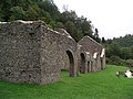
Forge near Montauban-sous-Buzenol
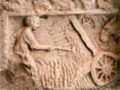
Treverer mower


Web links
Commons : Étalle, Belgium - Collection of images, videos and audio files