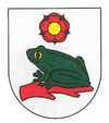
Žabokreky nad Nitrou
| Žabokreky nad Nitrou | ||
|---|---|---|
| coat of arms | map | |

|
|
|
| Basic data | ||
| State : | Slovakia | |
| Kraj : | Trenčiansky kraj | |
| Okres : | Partizánske | |
| Region : | Horná Nitra | |
| Area : | 6.977 km² | |
| Residents : | 1,739 (Dec. 31, 2019) | |
| Population density : | 249 inhabitants per km² | |
| Height : | 192 m nm | |
| Postal code : | 958 52 | |
| Telephone code : | 0 38 | |
| Geographic location : | 48 ° 38 ' N , 18 ° 18' E | |
| License plate : | PE | |
| Kód obce : | 505803 | |
| structure | ||
| Community type : | local community | |
| Administration (as of November 2018) | ||
| Mayor : | Cyril Cabadaj | |
| Address: | Obecný úrad Žabokreky nad Nitrou Školská 216 95852 Žabokreky nad Nitrou |
|
| Website: | www.zabokrekynadnitrou.sk | |
| Statistics information on statistics.sk | ||
Žabokreky nad Nitrou (until 1927 in Slovak "Nitrianske Žabokreky"; in Hungarian Nyitrazsámbokrét ) is a municipality in Slovakia . It is located in the Horná Nitra region in the valley of the river of the same name , 6 km west of the town of Partizánske .
The place was first mentioned in 1291 as Sebakereky .
In 2001 there were 1628 inhabitants in the place, of which 1596 were Slovaks .
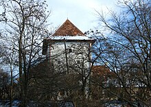
There is a Catholic church from 1913, a tower built around 1320 that was converted into a house in the 20th century, a curia from 1840 and a mausoleum from 1910.
Web links
Commons : Žabokreky nad Nitrou - collection of pictures, videos and audio files

