
Airvault (Airvault)
| Airvault | ||
|---|---|---|

|
|
|
| local community | Airvault | |
| region | Nouvelle-Aquitaine | |
| Department | Deux-Sèvres | |
| Arrondissement | Parthenay | |
| Coordinates | 46 ° 50 ′ N , 0 ° 8 ′ W | |
| Post Code | 79600 | |
| Former INSEE code | 79005 | |
| Incorporation | 1st January 2019 | |
| status | Commune déléguée | |
| Website | Airvault | |
 St-Pierre Church |
||

Airvault is a former French commune with 2,190 inhabitants (at January 1, 2017) in the department of Deux-Sèvres in the region Nouvelle-Aquitaine . It belonged to the Parthenay arrondissement and the canton of Le Val de Thouet . In Roman times the place was called Aurea Vallis ; In the Middle Ages, the spellings Oirevaud, Aureval, Ayrevau, Hervaut etc. were also used. a. common.
With effect from January 1, 2019, Airvault was merged with the municipality of Tessonnière to form Commune nouvelle Airvault of the same name and has the status of a Commune déléguée in the new municipality . At the same time, the former municipalities of Borcq-sur-Airvault and Soulièvres , which have been associated with Airvault as Communes associées since 1973 , were also granted the status of Commune déléguée. The administrative headquarters are in Airvault.
location
Airvault is located on the Thouet River at an altitude of approx. 110 m above sea level. d. M. about 55 kilometers (driving distance) northwest of Poitiers , 100 kilometers southwest of Tours and 97 kilometers southeast of Angers . Thouars is about 22 kilometers north.
Population development
On January 1, 1973, two formerly independent municipalities ( Borcq-sur-Airvault and Soulièvres ) merged with Airvault; The last two figures include the population of the two municipalities.
| year | 1800 | 1851 | 1901 | 1954 | 1999 | 2013 |
| Residents | 2,068 | 1,942 | 1,680 | 1,903 | 3,097 | 3,048 |
economy
In the Middle Ages, the small town benefited from the abbey, the castle and its location on the Way of St. James ; the residents lived from handicrafts, retail trade and other services. In the area around the village, agriculture dominated, which also included viticulture.
history
An old Roman road ran near Airvault , connecting Poitiers ( Limonum ) with Angers ( Juliomagus ). In the suburb of Soulièvres , the foundations of a Gallo-Roman country estate ( villa rustica ) from the 1st century AD were excavated. The St-Pierre Abbey was founded towards the end of the 10th century and subsequently expanded as a station on a branch line of the Camino de Santiago. In addition, the Vice Counts of Thouars had a castle here that was destroyed in the Wars of Religion (1569). With the decline in the flow of pilgrims to Santiago de Compostela during and after the Hundred Years War (1337-1453) and the Huguenot Wars (1562-1598), the place fell into a deep sleep.
Attractions
Former St-Pierre Abbey Church
( Monument historique since 1914)
Pont de Vernay
( Monument historique since 1868)
Others
.JPG)
- On the church square are the former post office, a half-timbered house ( maison à colombage ) from the 17th century with brick filling of the compartments, and an elongated, classicistic-looking market hall ( hall ) from the 18th or 19th century with a series of arcaded arches.
- Under the forecourt of the churches, an underground spring ( Fontaine souterraine ) with a mediaeval spring surround and a beautiful Romanesque barrel vault was "rediscovered" in the 19th century .
- A folklore museum ( Musée des Arts et Traditions Poitevines ) is housed in the former monastery buildings.
- About 150 m north of the former abbey church are the ruins of the castle ( château ) of the Vice Counts of Thouars. The building complex destroyed during the Huguenot Wars, from which the former gate tower deserves special mention, has been classified as a monument historique since 1929 .
- In the north-west of the city is the Chapelle St-Jérome , a former small Romanesque priory church from the 12th century.
- The privately owned Logis de Barroux ( 46 ° 49 ′ 47 ″ N , 0 ° 10 ′ 40 ″ W ) is a country estate from the 16th and 17th centuries that has a medieval look. It was recognized as a Monument historique in 1984 .
- To the south of Airvault are the Chapelle de l'Aumônerie (12th century) and the Chapelle des trois Maries (15th century).
- In the suburb of Soulièvres there is a pretty little castle in the historicizing style from 1851.

map
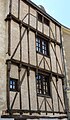
Half-timbered house

Market hall
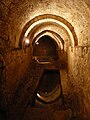
Underground spring


.JPG)
literature
- Thorsten Droste : The Poitou. Western France between Poitiers and Angoulême - the Atlantic coast from the Loire to the Gironde. DuMont, Cologne 1999, ISBN 3-7701-4456-2 , pp. 104-105.
- Henri Beauchet-Filleau: Histoire d'Airvault. M.-G. Micberth 1990 (reprint of the first edition from 1859) ISBN 978-2-87760-469-7 .
Web links
Individual evidence
- ↑ Decree of the Prefecture on the formation of the Commune nouvelle Airvault of December 6, 2018 .
- ↑ Airvault - Viticulture
- ↑ Abbaye Saint-Pierre, Airvault in the Base Mérimée of the French Ministry of Culture (French)
- ↑ Pont de Vernay, Airvault in the Base Mérimée of the French Ministry of Culture (French)
- ↑ Château, Airvault in the Base Mérimée of the French Ministry of Culture (French)
- ↑ Logis de Barroux, Airvault in the Base Mérimée of the French Ministry of Culture (French)