Allmendbach (Schäflibach)
|
Allmendbach upper course name: Vogelsangbächli |
||
|
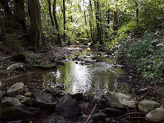
The Allmendbach near Ristenzmatt directly after crossing under the Birmensdorferstrasse |
||
| Data | ||
| Water code | CH : ZH100399 | |
| location | Switzerland | |
| River system | Rhine | |
| Drain over | Schäflibach → Limmat → Aare → Rhine → North Sea | |
| source | in the Gloggenmaas near Risi above Birmensdorf 47 ° 21 ′ 38 ″ N , 8 ° 26 ′ 22 ″ E |
|
| Source height | 505 m above sea level M. | |
| muzzle | near Urdorf in the Schäflibach coordinates: 47 ° 22 '43 " N , 8 ° 25' 32" E ; CH1903: 674 524 / 248010 47 ° 22 '43 " N , 8 ° 25' 32" O |
|
| Mouth height | 421 m above sea level M. | |
| Height difference | 84 m | |
| Bottom slope | 33 ‰ | |
| length | 2.5 km | |
| Catchment area | 2.21 km² | |
| Left tributaries | Cheibengraben | |
| Right tributaries | Wagenbach | |
| Communities | Birmensdorf , Urdorf | |
|
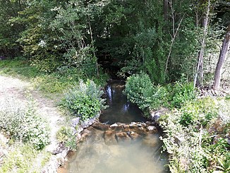
The Allmendbach directly after the retention basin of the same name |
||
The Allmendbach (in the upper reaches also Vogelsangbächli ) is an approximately 2.5 kilometers long left tributary of the Schäflibach in the Dietikon district of the Swiss canton of Zurich . It flows through the communities of Birmensdorf and Urdorf and always flows parallel to the Schäflibach, which runs a little to the east.
The brook was first mentioned as Schlaggbach on November 30, 1540 regarding the grazing between the two communities .
geography
course
The Allmendbach rises at 505 m above sea level. M. in the wetland Glogging Maas on Waldeggstrasse near the Risi district above Birmensdorf . The Gloggenmaas is bordered in the southern part by a semicircular moraine wall, which prevents the runoff into the Reppisch valley .
The brook drains the wetland underground to the north-northeast, where it crosses under the "Glogen" field after Waldeggstrasse. Here it is directed to the northwest, where a little later it runs directly under the Püntenmaas farm, in the vicinity of which the Püntenmoos moor used to extend. The Dolung now leads the Allmendbach to the west, where it crosses the fields of the «Roggenbach» and «Vogel» corridors. In doing so, he picks up the water that has been cleaned by the street sewage treatment plant (SABA).
Immediately after crossing under the embankment of the Zurich – Zug railway line , the stream occurs at Vogelsang at 476 m above sea level. M. lined with a small wood for the first time to the surface. It flows straight to the northwest and passes an asphalt mixing plant . It reaches Urdorferstrasse and twice crosses under a road that flows into it in a tight curve. In the green space enclosed by the roads, the stream runs open for around 20 meters and feeds a small pond. The Allmendbach reappears between Urdorferstrasse and a field path. It turns north-northeast and is bordered by a narrow strip of forest, which is bordered on the left bank by a tennis court and on the right bank by a dirt road.
After passing the tennis court, the forest spreads further and the stream turns to the northwest. Shortly afterwards it reaches the municipal boundary, which it forms for around 30 meters before it runs all the way into Urdorf . It flows in a meandering manner through the wooded area known as the «Gatter» and a little later reaches the road, which is now called Birmensdorfertrasse. At the same time, he crosses under this while the forest also moves to the other side of the road. It now flows to the north-northwest and follows the road that runs to the right at a little distance, while the Heinrich Stutz-Strasse, which borders the forest in the west, extends a little further away on the left. It crosses under a new, temporary connection road for public transport between the two streets and then reaches the Allmendrüti, which has been partially cleared. The Allmendbach is always lined with wood and shortly afterwards it crosses under the Schützenstrasse at the intersection with the Birmensdorferstrasse, before it emerges again in the also wooded Gmeindrüti.
After a few meters he turns to the east-north-east in order to cross under Birmensdorferstrasse again at the Rettetmatt. The Allmendbach takes there from the left with the Cheiben- resp. Tüchelroos ditch its main tributary. It flows through the wetlands nature reserve “Ristormatt-Tisliboll”, which also serves as a flood retention basin . There he passes a pond on the right bank fed by the Wagenbach, whose water he also absorbs. He turns to the northeast and passes the bottom outlet of the retention basin. Shortly afterwards a canal branches off on the left bank, which in addition to the Bollweiher also feeds a small pond.
The Allmendbach turns again to the north-northwest at the Bollweiher and resumes its drainage. Immediately afterwards the 90 meter long Bollbach flows from the left. Accompanied by thick wood, it now flows between the Boll on the left and the rubbish heaps falling on the right. It crosses under a dirt road and turns to the north-northeast, where the Wüestmatt now borders on the left bank.
Finally the Allmendbach meets 421 m above sea level. M. at the southern settlement boundary of Urdorf at the Weihermatt sports field, coming from the left and south-southwest onto the Stockacherbach, where it continues with the Schäflibach.
Catchment area
The catchment area of the Allmendbach measures 2.21 km², of which 37.4% is agricultural area, 35% wooded area and 27.5% settlement area. The highest point of the catchment area is 555 m above sea level. M. in the southern part of the Rameren forest area , the average altitude is 481 m above sea level. M. and the mean annual precipitation is 1060.63 mm. It extends completely over the neighboring communities of Birmensdorf and Urdorf in the Dietikon district .
Tributaries
The direct and indirect tributaries downstream
- Cheibengraben / Tüchelroosgraben ( left ), 0.69 km
- Wagenbach ( right ), 0.34 km
- Bollbach ( left ), approx. 0.9 km
environment
The Allmendbach flows through three supra-communal nature reserves, namely the wet location Glogin Maas , the dry location Bahndamm Ristenz and the wet location Ristormatt-Tisliboll . It also passes the Boll- Stockmatt ruderal site , which borders the left bank at the confluence of the Bollbach. Furthermore, the area around the source is registered in the geological-geomorphological inventory under the name Würmzeitlicher Moränenwall Glogenmas – Fürhoger – Risi .
flora
In the upper reaches of the brook (typical) maple - ash forest with bingelkraut and woodruff - beech forest with lungwort and forest ziest grows . At the middle course, the arum -beech forest and woodruff-beech forest line the stream and from the Allmendrüti again woodruff-beech forest.
Web links
- Course of the Allmendbach on GIS Zurich
- Course of the Allmendbach on the geoserver of the Swiss federal administration
- Geographic information system of the Canton of Zurich
Individual evidence
- ↑ a b c d Geographic information system of the Canton of Zurich
- ↑ a b c Topographical catchment areas of Swiss waters: sub-catchment areas 2 km². Retrieved October 23, 2017 .
- ↑ Lengths rounded to two decimal places


