Amieira do Tejo
| Amieira do Tejo | ||||||
|---|---|---|---|---|---|---|
|
||||||
| Basic data | ||||||
| Region : | Alentejo | |||||
| Sub-region : | Alto Alentejo | |||||
| District : | Portalegre | |||||
| Concelho : | Nisa | |||||
| Coordinates : | 39 ° 30 ′ N , 7 ° 50 ′ W | |||||
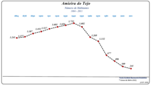
| Residents: | 232 (as of June 30, 2011) | |||||
| Surface: | 102.5 km² (as of January 1, 2010) | |||||
| Population density : | 2.3 inhabitants per km² | |||||
| Postal code : | 6050-103 | |||||
| politics | ||||||
| Mayor : | Francisco RogérioCardoso Dias | |||||
| Address of the municipal administration: | Junta de Freguesia de Amieira do Tejo Largo do Espírito Santo 6050-103 Amieira do Tejo |
|||||
Amieira do Tejo is a small town ( vila ) and former municipality in Portugal .
history
Antas and other finds prove a prehistoric settlement.
The Romans left numerous traces of their presence, as well as coins and ceramics as well as a bridge.
The present-day place was created in the course of the settlement policy at the end of the Portuguese Reconquista , when the young Kingdom of Portugal took large parts of the Alentejo from the Moors . The area went to the Hospitaller Order around 1194 , who founded various places in the region.
Amieira received its first town charter before 1256 . It became a vila and the seat of its own district. King Manuel I renewed the town charter in 1512 .
In the course of the administrative reforms after the Liberal Revolution in 1822 , the district was dissolved in the middle of the 19th century and incorporated as a municipality into the Nisa district. In contrast to a number of other Portuguese places with the name Amieira, the place has officially had the addition do Tejo since 1957 , referring to its proximity to the Tagus River .
With the territorial reform of 2013, the municipality of Amieira do Tejo was dissolved and merged with Arez .
Culture and sights
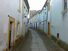
The most striking building in the village is the medieval castle Castelo de Amieira , which already existed in the middle of the 14th century. The town's architectural monuments also include a Roman bridge, the town hall built in 1682 with a characteristic balcony, and a large number of sacred buildings and historic houses.
The historic town center is also a listed building as a whole.
administration
Amieira do Tejo was the seat of a community of the same name ( freguesia ) in the district ( concelho ) of Nisa in the Portalegre district . 232 inhabitants lived in it on an area of 103 km² (as of June 30, 2011).
The following villages are located in the former municipality:
- Albarrol
- Alto da Taipa
- Amieira do Tejo
- Barragem do Fratel
- Vila Flor
In the course of the regional reform of September 29, 2013 , the municipality of Amieira do Tejo was dissolved and merged with Arez to form the new municipality of União das Freguesias de Arez e Amieira do Tejo .
Web links
- Website of the municipality at Kreis
- Unofficial website about Amieira do Tejo
- Entry to Amieira do Tejo in the Mapas de Portugal
Individual evidence
- ↑ a b www.ine.pt - indicator resident population by place of residence and sex; Decennial in the database of the Instituto Nacional de Estatística
- ↑ Overview of code assignments from Freguesias on epp.eurostat.ec.europa.eu
- ↑ www.monumentos.pt (under Cronologia ), accessed on July 24, 2013
- ↑ ditto
- ↑ www.amieiradotejo.home.sapo.pt ( Memento of the original from March 9, 2016 in the Internet Archive ) Info: The archive link was inserted automatically and has not yet been checked. Please check the original and archive link according to the instructions and then remove this notice. , accessed July 24, 2013
- ↑ www.monumentos.pt , accessed on July 24, 2013
- ↑ ditto
- ↑ ditto
- ↑ ditto


