Archangai aimag
| Archangai-Aimag Архангай Аймаг |
|||||
|---|---|---|---|---|---|
|
|||||
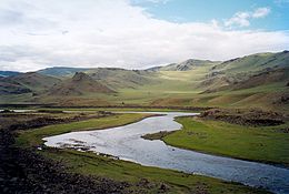
 Landscape in the Tariat sum |
|||||
| Founded: | 1931 | ||||
| Main place: | Tsetserleg | ||||
| Surface: | 55,300 km² | ||||
| Residents: | 93,509 (2016) | ||||
| Population density: | 1.76 inhabitants / km² | ||||
| Telephone code: | +976 (0) 133 | ||||
| License Plate: | АР_ (_ variable) | ||||
| ISO 3166-2 : | MN-073 | ||||
| Offic. Website: | [http: // arkhangai.gov.mn arkhangai.gov.mn ] | ||||
| Location of the Archangai aimag in Mongolia | |||||
Coordinates: 47 ° 30 ' N , 101 ° 30' E

The Archangai aimag ( Mongolian Архангай Аймаг ) is an aimag (province, region) of Mongolia and is located a little west of the center of the country.
The name of this aimag means "North Changai" and alludes to the location on the north side of the Changai Mountains .
geography
The Archangai aimag lies in the interior of the country and borders on the following aimags: Bulgan (northeast), Öwörchangai (southeast), Bajanchongor (south), Dsawchan (west) and Chöwsgöl (northwest).
Waters
The rivers Chuluut , Chanui and Tamir originate in the valleys of the Changai in the Archangai , all of which belong to the catchment area of the Selenge with a few smaller tributaries . In addition, the Orkhon flows for a short distance through the eastern end of the territory.
In the west is the Chorgo Terchiin Tsagaan Nuur National Park with the Tsagaan Nuur lake , around which an interesting legend is entwined. A giant is said to have grabbed a large boulder and thrown it away. When he looked back, he saw a bright surface and exclaimed in astonishment: "Look, a white lake!". The exclamation has been preserved as the name of the lake. The boulder is further east and is named Taichar Tschuluu . The small lake Ögii Nuur is located in the far east in the Sum of the same name.
traffic
Tsetserleg Airport (ZMTG / TSZ) has an unpaved runway and offers regular connections to and from Ulan Bator .
Administrative structure
The capital Tsetserleg is geographically located in Bulgan Sum in the south of the Aimag, but is administered as an independent municipality. Nor should it be confused with Tsetserleg-Sum in the north.
| Sum | Mongolian | Population (2008) |
Population (2009) |
Sum center population |
|---|---|---|---|---|
| Bat-tsengel | Батцэнгэл | 3,855 | 3.846 | 1,096 |
| Bulgan | Булган | 2.361 | 2,434 | 961 |
| Earth Bulgan * | Эрдэнэбулган | 18.022 | 17.770 | 17.770 |
| Chairchan | Хайрхан | 3.558 | 3.656 | 739 |
| Changai | Хангай | 2.805 | 2.926 | 795 |
| Chaschaat | Хашаат | 3.305 | 3,344 | 802 |
| Chotont | Хотонт | 4.809 | 4,440 | 774 |
| Jargalant | Жаргалант | 4,114 | 4.111 | 1.035 |
| Earth mandate | Эрдэнэмандал | 5.843 | 5.933 | 1.091 |
| I-Tamir | Их тамир | 5.154 | 5.247 | 1.050 |
| Tariat | Тариат | 5.022 | 5.086 | 644 |
| Tschuluut | Чулуут | 3.749 | 3.744 | 935 |
| Tsachir | Цахир | 2.126 | 2.143 | 438 |
| Ögii only | Өгий нуур | 3.041 | 3.086 | 622 |
| Öldsiite | Өлзийт | 3.037 | 3.102 | 829 |
| Öndör-Ulaan | Өндөр-Улаан | 5.729 | 5.798 | 1.097 |
| Töwschrüülech | Төвшрүүлэх | 3.410 | 3.438 | 1,869 |
| Tsencher | Цэнхэр | 5.387 | 5.414 | 997 |
| Tsetserleg | Цэцэрлэг | 3,955 | 3.813 | 848 |
* - The capital, Tsetserleg of the Aimag
Web links
Individual evidence
- ↑ Arkhangai Aimag 2008 December Statistical Report ( page no longer available , search in web archives ) Info: The link was automatically marked as defective. Please check the link according to the instructions and then remove this notice.
- ↑ Dec. 31 2009 estimation. Arkhangai Aimag Statistical Service ( Memento from July 22, 2011 in the Internet Archive )


