Attalla
| Attalla | |
|---|---|
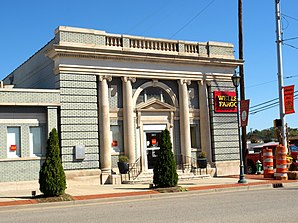
 US Post Office Attalla (2009) |
|
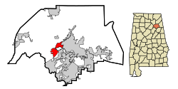
| Location in Alabama | |
| Basic data | |
| Foundation : | 1870 |
| State : | United States |
| State : | Alabama |
| County : | Etowah County |
| Coordinates : | 34 ° 1 ′ N , 86 ° 6 ′ W |
| Time zone : | Central ( UTC − 6 / −5 ) |
| Residents : | 6,048 (as of 2010) |
| Population density : | 349.6 inhabitants per km 2 |
| Area : | 17.3 km 2 (approx. 7 mi 2 ) of which 17.3 km 2 (approx. 7 mi 2 ) is land |
| Height : | 166 m |
| Postal code : | 35954 |
| Area code : | +1 256 |
| FIPS : | 01-03028 |
| GNIS ID : | 0157880 |
| Website : | www.attallacity.com |
 Bank in the Attalla Downtown Historic District (2014) |
|
Attalla is a city in Etowah County in the state of Alabama in the United States .
geography
Attalla is located in northeast Alabama in the southern United States. It is about midway between the 733 square kilometer William B. Bankhead National Forest and the 1,600 square kilometer Talladega National Forest .
Nearby places include Gadsden (immediately to the east), Rainbow City (immediately to the south), Ridgeville (2 km to the north), Ivalee (3 km to the northwest) and Southside (7 km to the southeast). The next larger city with 212,000 inhabitants is about 50 kilometers southwest of Birmingham .
history
The first settler in this area can be proven in 1800, and the founding of the city goes back to him. In 1819 the first post office was opened under the name Bennettville , based on a property owner. The first mines were opened in 1830, and the first church followed in 1851. For a short time the city was called The Junction (German Die Kreuzung ) before it was called Bainsville in 1866 . In 1870 the first local newspaper Union Republic was founded.
The construction of several railway lines to and through Attalla made the city a regional transport hub. The first schools were founded in 1872. The flourishing steel industry was supplemented by the production of cotton and construction timber at the turn of the century. In 1891 the city was largely destroyed by a fire.
In 1892 the city received its current name. In 1903, Lock 12 Dam was built to generate hydropower.
Two locations in Attalla are listed on the National Register of Historic Places (as of November 15, 2019), the US Post Office Attalla and the Attalla Downtown Historic District .
traffic
US Highways 11 , 278 and 431 run through Attalla, and Interstate 59 , which runs 715 kilometers from Louisiana to Georgia , runs in the southeast and east of the city .
Birmingham-Shuttlesworth International Airport is around 75 kilometers to the southwest .
Demographics
The 2000 census showed a population of 6,795, divided into 2,672 households and 1976 families. The population density was 382 people per square kilometer. 78.4% of the population were whites, 13.5% blacks, 1.5% Indians and 0.1% Asians. 1.6% were of another ethnicity , 0.7% had two or more races, 2.2% were Hispanics or Latin Americans of any ethnicity. For every 100 women there were about 90 men. The median age was 38 years and the per capita income was 15,727 US dollars, which put about 18.6% of the population below the poverty line.
By the 2010 census , the population had dropped to 6,048.
Personalities
- Betty Kelly (* 1944), former soul singer
- Larry Means (* 1947), politician and senator
- Cadillac Williams (* 1982), former football player
Individual evidence
-
↑ Search mask database in the National Register Information System. National Park Service , accessed November 15, 2019.
Weekly List on the National Register Information System. National Park Service , accessed November 15, 2019.
Web links
- Official website (English).
- Statistical data on Attalla (Engl.)
- Attalla, Encyclopedia of Alabama (Engl.)
