Aube (river)
| Aube | ||
| Data | ||
| Water code | FR : F1-0200 | |
| location | France , Bourgogne-Franche-Comté and Grand Est regions | |
| River system | His | |
| Drain over | Its → English Channel | |
| source | in the municipality of Auberive, 47 ° 45 ′ 39 ″ N , 5 ° 7 ′ 24 ″ E |
|
| Source height | approx. 378 m | |
| muzzle | at Marcilly-sur-Seine in the Seine coordinates: 48 ° 33 ′ 28 " N , 3 ° 42 ′ 56" E 48 ° 33 ′ 28 " N , 3 ° 42 ′ 56" E |
|
| Mouth height | approx. 68 m | |
| Height difference | approx. 310 m | |
| Bottom slope | approx. 1.2 ‰ | |
| length | approx. 249 km | |
| Catchment area | 4595 km² | |
| Left tributaries | Aubette , Coupe-Charme , Landion , Amance , Auzon , Barbuise | |
| Right tributaries | Aujon , Bresse , Voire , Meldançon , Ravet , Puits , Huitrelle , Herbissonne , Salon , Superbe | |
| Small towns | Bar-sur-Aube | |
|
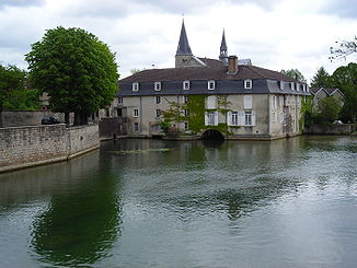
The Aube at Bar-sur-Aube |
||
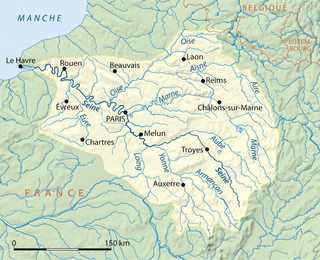
The Aube is a river in France . Its source is on the Langres plateau , in the municipality of Auberive , at an altitude of 378 meters. It generally drains north-west and flows into the Seine as a right tributary after around 249 kilometers at Marcilly-sur- Seine . The French department of Aube is named after the river . It flows through the Forêt d'Orient Regional Nature Park .
Crossed departments
in the Grand Est region :
in the Bourgogne-Franche-Comté region :
Places on the river
- Auberive
- Montigny-sur-Aube
- Laferté-sur-Aube
- Ville-sous-la-Ferté
- Bar-sur-Aube
- Dienville
- Brienne-la-Vieille
- Arcis-sur-Aube
- Plancy-l'Abbaye
- Anglurs
- Marcilly-sur-Seine
Hydrology
In the Forêt d'Orient Regional Nature Park, two lakes have been artificially created, which serve as a retention basin for the Aube, prevent Paris from being flooded when the water flow is strong , and compensate for the maintenance of shipping when the water flow is low . They are connected to the river by inlet and outlet channels. They are:
- Lac d'Auzon-Temple (surface: 20 km², volume: 148 million m³, commissioning: 1990)
- Lac Amance (surface: 5 km², volume: 22 million m³, commissioning: 1990)
See also
Web links
- Forêt d'Orient Regional Nature Park (French)
Individual evidence
- ↑ Source geoportail.gouv.fr ( Note: The French water database SANDRE still counts the southern source stream in the course of the Aube.)
- ↑ estuary geoportail.gouv.fr
- ↑ a b Water information system Service d'Administration National des Données et Référentiels sur l'Eau (French) ( information ), accessed on June 30, 2018, rounded to full kilometers.


