
Autoceļš A5
| Autoceļš A5 in Latvia | |

|
|
| |
|
| map | |
 |
|
| Basic data | |
| Operator: |
|
| Start of the street: |
Salaspils ( 56 ° 51 ′ N , 24 ° 19 ′ E ) |
| End of street: |
Babīte ( 56 ° 58 ′ N , 23 ° 57 ′ E ) |
| Overall length: | 40.9 km |
 |
|
| A5 at Babīte , 2010 | |
Autoceļš A5 is one of Latvia's state highways "State Main Road" ( Lat .: Valsts galvenie A utoceļi ). It leads from a motorway triangle with the A6 at Salaspils over a motorway junction with the Latvian A10 and ends in the urban area of Babīte . The A5 is part of the European roads 22 , 67 and 77 . The A5 represents the southwest bypass road of Riga.
The total length is 40.9 kilometers. The section between Salaspils and a motorway junction with the A9 at Brīvkalni is the road with a total of two lanes and one lane. From the motorway junction to the end of the road in Babīte , the road is a motorway with two lanes per lane. A road bridge over the Daugava is located at the Riga hydropower plant . In this area the road runs along the reservoir. The section between the junction with the A8 and the junction with the A9 is currently (January 2012) being modernized. A new construction of the road bridge over the Düna is planned in the planned further course of the A4 . The maximum speed is currently set at 90 km / h. The average traffic volume is 8196 vehicles per day in 2011.
Important places along the route
gallery
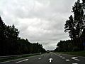
The A5 at Piņķi , 2010.

Web links
- Website of the company "Latvian State Roads " (Lat./Engl.)
- The course of the Autoceļš A5 on maps.google.com
Individual evidence
- ↑ Overview of all main streets on lvceli.lv (English)
- ↑ Valsts galveno autoceļu segu reconstructkcijas programma 2010. - 2012. gads ( page no longer available , search in web archives ) Info: The link was automatically marked as defective. Please check the link according to the instructions and then remove this notice. (Latvian; PDF; 705 kB)