
Balatan
| Municipality of Balatan | |||
| Location of Balatan in the Camarines Sur province | |||
|---|---|---|---|

|
|||
| Basic data | |||
| Region : | Bicol region | ||
| Province : | Camarines Sur | ||
| Barangays : | 17th | ||
| District: | 4. Camarines Sur district | ||
| PSGC : | 051702000 | ||
| Income class : | 4. Income bracket | ||
| Households : | 4141 May 1, 2000 census
|
||
| Population : | 30,922 August 1, 2015 census
|
||
| Population density : | 485.3 inhabitants per km² | ||
| Area : | 63.720 km² | ||
| Coordinates : | 13 ° 19 ′ N , 123 ° 14 ′ E | ||
| Postal code : | 4436 | ||
| Mayor : | Nena B. Borja | ||
| Geographical location in the Philippines | |||
|
|||

Balatan is a Filipino municipality in the Camarines Sur Province .
Balatan was founded by Don Gregorio Balatan, he was also the first mayor of the place and founder of the first school, the Balatan Institute . Nena B. Borja is currently the mayor.
Balatan regularly celebrates a festival on February 18th. The municipality is located on the coast of the Gulf of Ragay .
Barangays
Balatan is politically in 17 barangays divided.
|
Photo gallery
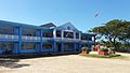
Balatan City Hall

Don Gregorio O. Balatan, founder of the city
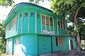
Don. Gregorio Balatan Memorial Institute
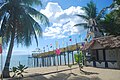
A seaside resort in Balatan


