Caramoan
| Municipality of Caramoan | ||
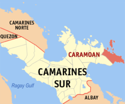
| Location of Caramoan in the Camarines Sur province | ||
|---|---|---|

|
||
| Basic data | ||
| Region : | Bicol region | |
| Province : | Camarines Sur | |
| Barangays : | 49 | |
| District: | 3. District of Camarines Sur | |
| PSGC : | 051711000 | |
| Income class : | 2nd income bracket | |
| Households : |
May 1, 2000 census
|
|
| Population : | 47,605 August 1, 2015 census
|
|
| Population density : | 172.5 inhabitants per km² | |
| Area : | 276.00 km² | |
| Coordinates : | 13 ° 46 ′ N , 123 ° 52 ′ E | |
| Postal code : | 4429 | |
| Geographical location in the Philippines | ||
|
|
||
Caramoan is a Filipino municipality in the province of Camarines Sur , in the administrative region V, Bicol. It has 47,605 inhabitants (August 1, 2015 census) who lived in 49 barangays . It is located on the Caramoan Peninsula , its neighboring communities are Garchitorena and Presentacion in the west. To the east is the island province of Catanduanes . In the north the community borders on the Philippine Sea , on which lies the Caramoan National Park , and in the southeast on the Gulf of Lagonoy .
The municipality includes the islands of Lahuy , Basot , Basog , Bagieng and Lucsuhin Island .
Barangays
|
|
|
