Tigaon
| Municipality of Tigaon | ||
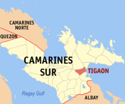
| Location of Tigaon in the Camarines Sur province | ||
|---|---|---|

|
||
| Basic data | ||
| Region : | Bicol region | |
| Province : | Camarines Sur | |
| Barangays : | 23 | |
| District: | 3. District of Camarines Sur | |
| PSGC : | 051736000 | |
| Income class : | 4. Income bracket | |
| Households : | 8650 May 1, 2000 census
|
|
| Population : | 55.272 August 1, 2015 census
|
|
| Population density : | 503 inhabitants per km² | |
| Area : | 109.88 km² | |
| Coordinates : | 13 ° 39 ′ N , 123 ° 31 ′ E | |
| Postal code : | 4420 | |
| Mayor : | Arnie Fuentebella | |
| Website: | www.tigaon.gov.ph | |
| Geographical location in the Philippines | ||
|
|
||
Tigaon is a Filipino municipality in the Camarines Sur province . It lies between the 1,966-meter-high Mount Isarog, overgrown with primeval forest, and the beaches of the Gulf of Lagonoy . The next major city is Naga City .
The people live mainly from agriculture (rice, corn, sugar cane, Abaca / Manila hemp, bananas) and fishing.
Barangays
Tigaon is divided into 23 barangays .
|
|
