Garchitorena
| Municipality of Garchitorena | ||
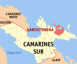
| Location of Garchitorena in the Camarines Sur province | ||
|---|---|---|

|
||
| Basic data | ||
| Region : | Bicol region | |
| Province : | Camarines Sur | |
| Barangays : | 23 | |
| District: | 3. District of Camarines Sur | |
| PSGC : | 051714000 | |
| Income class : | 4. Income bracket | |
| Households : | 3873 May 1, 2000 census
|
|
| Population : | 27.010 August 1, 2015 census
|
|
| Population density : | 123.8 inhabitants per km² | |
| Area : | 218.12 km² | |
| Coordinates : | 13 ° 53 ' N , 123 ° 42' E | |
| Mayor : | Solon O Demetriois, Jr. | |
| Geographical location in the Philippines | ||
|
|
||
Garchitorena is a Filipino municipality in the Camarines Sur province . It has 27,010 inhabitants (August 1, 2015 census). The municipality is located on the mountainous Caramoan Peninsula , on the coast of the Philippine Sea . Their neighboring communities are Caramoan in the east, Presentacion in the southeast and Lagonoy in the west.
The administrative area of the municipality includes the islands of Quinalasag , Matanga , Malabungut and Lamit Islands .
Barangays
Garchitorena is politically divided into 23 barangays .
|
|
