
Bayerwald trail
The Bayerwaldloipe is a long-distance skiing trail in the Bavarian Forest . The trail begins in the Osser area near Lohberg and ends in Neureichenau in the Dreisessel area . It is made up of cross-country trails for the individual ski resorts and connecting pieces; some gaps must be covered on foot. The total length is approximately 140 km. Since the cross-country ski trail partly runs through quite deep areas (Zwiesel 582 m), it is only considered snow-sure in high winter.
course
Due to a number of sections with a one-way regulation, the Bayerwaldloipe can only be used in one direction, from northwest to southeast.
The entrance at the cross-country skiing center is on the Lam - Bayerisch Eisenstein bus line . Further to the north-west it is possible to start in Eggersberg near Lam (red marked trail to Scheiben, difficult); this allows the total distance to be extended by 9 km.
Course and possible stage locations:
- Discs - Bayerisch Eisenstein . 11 km.
- on the Hohenzollern trail via Steinhütte, Hintere Steinhütte to Arberhütte. Through the Regental to Regenhütte . On the Kaisersteig to Rabenstein . Departure to Zwiesel . 21 km.
- The trail begins again on the southern outskirts of Zwiesel ( Glasberg or Bärnzell ; possibly ski bus or city bus). Pretty straightforward to Spiegelau on forest roads . After the first third, the local trails from Frauenau (north) and Rinchnach (south) are touched at the Josefi chapel . 16 km.
- From Spiegelau first direction NE into the national park, Jägerfleck, then direction SE to Riedlhütte, crossing the Große Ohe , Höhenbrunn, Bärwurzhütte, Sankt Oswald (possible stage). Direction S to the Grafenau cross-country skiing center Rosenau, then east on the national park trail to Neuschönau . 17 km.
- First direction S to Sägmühle, then continue through the municipality of Hohenau towards E, pass Kirchl and Schönbrunn am Lusen to the south, on Reschwasser towards NE to Mauth . 21 km.
- On the Dreikönigsloipe in the national park, Finsterau . Possibility of a detour to the Czech Republic (Moldau source, Kvilda ). Regularly further east to the Hammerklausen trail , then direction SO to Mitterfirmiansreut . 23 km.
- Via Philippsreut to Bischofsreut , ascent to 1140 m, Leopoldsreut desert , Haidel lookout tower, Kreuzfichte-Osterbach, Frauenberg cross-country ski center, Altreichenau , Neureichenau . 30 km (alternatively, an intermediate descent with an overnight stay in Haidmühle after 18 km).
- Possibility to extend by approx. 10 km from Altreichenau to Lackenhäuser .
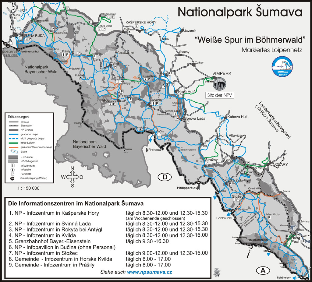
Circuit through the Bavarian and Bohemian Forest
In the Czech Šumava National Park there is a dense network of cross-country trails that can be accessed via the border crossings Bayerisch Eistenstein, Ferdinandsthal, Finsterau / Bucina, Philippsreut / Silnice, Marchhäuser, Haidmühle. This gives you the opportunity to run a circuit of 200 km and more.
practical information
- cards
- Fritsch hiking map, No. 5 "Bavarian Forest", 10th edition, scale 1: 100,000, with cross-country trails.
- Land survey office, scale 1: 50,000, without cross-country trails. Compilation UK 50-29 (Scheiben - Bischofsreuth). The last 15 km on UK 50-30. The alternative entry at Lam on UK 50-27.
- Snow depths
- Snow phone 08558 91021.
- Web pages
- "Official" website with poor content, but a useful link to a private website with a snow report
- Directions
- Excellent compilation of links
- Municipal website with a proper trail plan for the national park region
- Tour reports
Footnotes
- ↑ The often stated length of 150 km comes together if you add extension options at the beginning or end.
- ↑ http://www.langlaufen-bayrischer-wald.de/de/bayerwaldloipe.html
- ↑ http://www.skiwanderzentrum.de/DE/pics/loipenkarte_sumava.jpg Cross-country ski trail map of the Czech National Park Šumava.