Belize City
| Belize City | ||
|---|---|---|
|
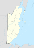
Coordinates: 17 ° 30 ′ N , 88 ° 11 ′ W Belize City on the map of Belize
|
||
| Basic data | ||
| Country | Belize | |
| District | Belize District | |
| City foundation | 17th century | |
| Residents | 62,582 (2017) | |
| Detailed data | ||
| height | 0 m | |
| City structure | 5 | |
| Waters | Caribbean | |
| Time zone | UTC −6 | |
| City Presidency | Darrel Bradley | |
| Website | ||
| Belize City aerial view | ||
| The City Hall in Belize City | ||
Belize City ( Eng. Belize City ) is the largest city and main port of Belize (formerly British Honduras). It has around 63,000 residents and is the provincial capital of the Belize District region .
Belize City is the seat of the Diocese of Belize City-Belmopan .
geography
The city consists of the districts:
- Fort George,
- King's Park,
- Newtown Barracks,
- Port Loyola,
- West Canal.
The Haulover Creek, an estuary of the Belize River , divides the city in half, Northside and Southside.
history
The city was founded as "Belize Town" in the middle of the 17th century by British workers as a logging settlement. Belize City was the capital of what was then British Honduras until 1970 . After the city on the coast of the country was almost completely destroyed by Hurricane Hattie in 1961 , the government decided to move the seat of government and began building a new capital inland. In 1975 the seat of government was moved to Belmopan . Belize City is the capital of the Belize District Province. As the largest and most populous city in the country, Belize City continues to be the economic and cultural center of the Central American state.
Attractions
- The Belize Swing Bridge in the city center was built in 1923 and is one of the few swing bridges in the world that is still moved daily by human hands. It connects the two halves of the city, Northside and Southside.
- The Maritime Museum is located in the Belize Maritime Terminal near the Swing Bridge. Exhibits revolve around fishing, boats and the Belize Reef.
- Not far from the Maritime Museum on North Front Street is the Image Factory art museum with work by local artists.
- The Fort George neighborhood is home to some popular Belize City attractions, including B. the colonial town hall, the Queen Street Baptist Church, the old US embassy and the lighthouse at Fort George harbor.
- On the corner of Albert Street and Regent Street is St. John's Cathedral, built in 1847, the oldest Anglican church in Central America.
- Opposite St. John's Cathedral is the government building, a colonial building built in 1814 .
politics
The United Democratic Party (UDP) has ruled Belize City since March 1, 2006 . Mayor is Darrell Bradley, who was elected on March 7, 2012.
population
Haulover Creek, an estuary of the Belize River, divides the city in two, called Northside and Southside. In the Southside part is the commercial and economic center of Belize City (bounded by the streets Albert, Regent, King and Orange Street) as well as residential areas with a poor population and high crime rate. On the north half are the more upscale residential and hotel areas of Fort George and King's Park.
| year | population |
|---|---|
| 1980 | 39,771 |
| 1991 | 44,087 |
| 2000 | 49,456 |
| 2010 | 57,169 |
| 2018 | 63,423 |
traffic
Belize City is the main transportation hub in the country. In the Southside part of the city, near the city center, is the largest bus station in the country. Virtually every major location in the country can be reached from Belize City. Buses to neighboring Guatemala also start in Belize City. The Philip SW Goldson International Airport (BZE, MZBZ) is located near Belize City, in neighboring Ladyville . The islands in the Belize Barrier Reef , which are very important for tourism in the country, can be reached by so-called water taxis from Belize City. The Western Highway connects Belize City with the capital Belmopan. The Northern Highway connects Belize City with the Mexican border (Corozal).
sport and freetime
Belize City has two football clubs in the Belize Premier Football League , the country's first division: the Belizean champions of 2005 and 2006, FC Belize , and the club Belize Defense Force , both of which play their home games at the MCC Grounds in the north of the city.
The Belize Zoo is located halfway between Belize City and Belmopan and is the largest zoo in Belize. Around 125 animal species from the region can be seen here.
Town twinning
Sister cities of Belize City are
|
|
sons and daughters of the town
- George Cadle Price (1919–2011), Prime Minister of Belize (1981–1984)
- Elmira Minita Gordon (* 1930), British politician, Governor General of Belize
- Manuel Esquivel (* 1940), Prime Minister of Belize (1984–1989)
- Edward Arthur Laing (1942–2001), lawyer, from 1996 to 2001 judge at the International Tribunal for the Sea
- Dorick McGowan Wright (1945–2020), Roman Catholic clergyman, Bishop of Belize City-Belmopan
- Wilfred Elrington (born 1948), politician
- Verno Phillips (* 1969), American professional boxer
- Arlen Escarpeta (born 1981), actor
- Deon McCaulay (born 1987), football player
Web links
proof
- ^ Belize: Districts, Towns & Villages - Population Statistics, Maps, Charts, Weather and Web Information. Retrieved November 25, 2017 .
- ↑ Belize: Districts, Cities & Villages - Population Statistics, Maps, Charts, Weather and Web Information. Retrieved August 3, 2018 .
- ^ Belize City Council website


