Betim
| Município de Betim "Cidade Industrial"
Betim
|
|||
|---|---|---|---|
|
|
|||
| Coordinates | 19 ° 58 ′ S , 44 ° 12 ′ W | ||
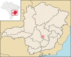
 Location of Betim in the state of Minas Gerais Location of Betim in the state of Minas Gerais
|
|||
| Symbols | |||
|
|||
| founding | 1711 (first settlement) December 17, 1938 (city foundation) |
||
| Basic data | |||
| Country | Brazil | ||
| State | Minas Gerais | ||
| ISO 3166-2 | BR-MG | ||
| Região intermediária | Belo Horizonte | ||
| Região imediata | Belo Horizonte | ||
| Metropolitan area | Belo Horizonte | ||
| height | 860 m | ||
| Waters | Rio Paraopeba , Rio Betim | ||
| climate | Cwa, tropical mountain climate | ||
| surface | 343.9 km² | ||
| Residents | 378,089 (2010) | ||
| density | 1,099.6 Ew. / km² | ||
| estimate | 439,340 Ew. (July 1, 2019) | ||
| Parish code | IBGE : 3106705 | ||
| Time zone | UTC −3 | ||
| Website | prefeiturabetim (Brazilian Portuguese) | ||
| politics | |||
| City Prefect | Vittorio Medioli (2017-2020) | ||
| Political party | Partido Humanista da Solidariedade (PHS) | ||
| Culture | |||
| Patron saint | Nossa Senhora do Carmo | ||
| City festival | July 16: Feast of the city's patroness November 20: Dia da Consciência Negra (Blackness Awareness Day) |
||
| economy | |||
| GDP | 23,904,767 thousand R $ 57,283 R $ per person (2015) |
||
| HDI | 0.749 (2010) | ||
Betim , officially Portuguese Município de Betim , is a city in the Brazilian state of Minas Gerais . It belongs to the metropolitan region of Belo Horizonte . In 2019, an estimated 439,340 people, called Betinese ( betinenses ), lived in Betim on around 344 km². It is 26 km from the capital, Belo Horizonte .
history
The history of the place begins in 1711 with the establishment of a chapel here by the bandeirante Joseph Rodrigues Betim, who gave the city its name. It was on the road connecting São Paulo and Pitangui , which was used by the Bandeirantes. It received city rights on December 17, 1938.
geography
Surrounding places are: Contagem , Esmeraldas , Igarapé , Ibirité , São Joaquim de Bicas , Mário Campos , Juatuba and Sarzedo .
The transport connection is via the state and federal highways MG-060 , MG-050 , BR-381 , BR-040 and BR-262 .
climate
The city has a tropical mountain climate (Cwa) according to the Köppen and Geiger climate classification. The average temperature is 21.1 ° C. The average rainfall is 1369 mm per year. The summer in Betim is much more humid than the winter.
Average monthly temperatures and rainfall for Betim
| Jan | Feb | Mar | Apr | May | Jun | Jul | Aug | Sep | Oct | Nov | Dec | |||
| Temperature ( ° C ) | 23.5 | 23.3 | 22.1 | 20th | 18.4 | 17.8 | 18.9 | 20.4 | 21.7 | 22.6 | 22.7 | 21.7 | O | 21.1 |
| Precipitation ( mm ) | 262 | 152 | 151 | 63 | 25th | 12 | 13 | 10 | 38 | 121 | 230 | 292 | Σ | 1369 |
Hydrography
The most important rivers that cross the municipality are the Rio Paraopeba and its tributary Rio Betim .
City administration
Executive: City prefect (mayor) has been Vittorio Medioli of the Partido Humanista da Solidariedade (PHS) since the local elections in 2016 for the term 2017 to 2020 . The legislature lies with a city council, the Câmara Municipal, made up of 23 elected city councilors. Edson Leonardo Monteiro , known as Léo Contador, of the Democratas is president for the city's 18th legislative period from 2017 .
economy
The gross domestic product per capita in 2008 was R $ 58,938 (approx. 1.5 times the Brazilian average). Betim owes an economic upturn in the 1960s to the oil refinery Refinaria Gabriel Passos and a plant of the automobile manufacturer Fiat Automoveis .
Personalities
Athletes born in Betim:
- Jonathas (actually Jonathas Cristian de Jesus Maurício, * 1989), football player
Web links
- City Prefecture website , Prefeitura Municipal (Brazilian Portuguese)
- City Council website , Câmara Municipal (Brazilian Portuguese)
Individual evidence
- ↑ IBGE : Betim - Panorama. Retrieved September 28, 2018 (Brazilian Portuguese).
- ↑ Betim - História. In: cidades.ibge.gov.br. IBGE , accessed September 28, 2018 (Brazilian Portuguese).
- ↑ Climate data , accessed on May 15, 2018.
- ^ Vittorio Medioli 31 (Prefeito). In: todapolitica.com. Eleições 2016, accessed November 3, 2019 (Brazilian Portuguese).


