Beutenbach (Lindenbach)
|
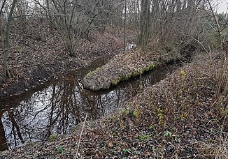
Beutenbach lower course: Scheffzengraben |
||
|
Aischbach and Schnatzgraben merge to form the Beutenbach |
||
| Data | ||
| Water code | DE : 2384662 | |
| location |
Neckar basin
Upper reaches:
|
|
| River system | Rhine | |
| Drain over | Lindenbach → Glems → Enz → Neckar → Rhine → North Sea | |
| origin | Confluence of einzugsgebietsreicherem left Aischbach and longer right Schnatzgraben 48 ° 48 '52 " N , 9 ° 4' 51" O |
|
| Source height | approx. 307 m above sea level NN Zsfl. Aischbach / Schnatzgraben |
|
| muzzle | In Ditzingen opposite the building Ditzenbrunner Straße 6 from the left into the Lindenbach named Lachengraben coordinates: 48 ° 49 '41 " N , 9 ° 4' 16" E 48 ° 49 '41 " N , 9 ° 4' 16" E |
|
| Mouth height | approx. 296 m above sea level NN | |
| Height difference | approx. 11 m | |
| Bottom slope | approx. 1.5 ‰ | |
| length | 7.3 km with OL Schnatzgraben |
|
| Catchment area | 15.673 km² | |
The Beutenbach is a left tributary of the Lindenbach in the settlement area of the city of Ditzingen in the Baden-Württemberg district of Ludwigsburg, a little before its confluence with the Glems in the right floodplain.
course
The Beutenbach arises in the course of its name immediately west of the Stuttgart district of Hausen from the union of the Aischbach (Grundgraben) coming from Gerlingen with the Schnatzgraben (Rappach). The Beutenbach flows through the Scheffzental nature reserve and flows into the Lindenbach in the city of Ditzingen . The lower course is partially dotted and built over with the Ditzinger Stadthalle.
In sections the Beutenbach was still called Weidenbach in the 16th century . The Ditzinger Flur to the east of the stream is called the Beutenfeld.
Booty mill
The names Beutenbach and Beutenfeld are derived from the Beutenmühle , whose 785 meter long mill channel branched off from the Beutenbach in the upper Scheffzental. The mill is first mentioned around 1350 as Bittenmülin . The plant, which fell into desolation in the Thirty Years' War , was renovated in 1655 and operated as a flour mill until the 20th century. After a major fire that completely destroyed the mill in 1914, the businessman Alfred Dobelmann had a new residential and factory building built with an overshot water wheel , which was used to drive woodworking machines for shoe production (Dobelmann shoe factory in Ditzingen) and a screw factory. In 1956 the right to use water was replaced by the municipality of Ditzingen and repealed upon their application. The Mühlkanal was filled in or leveled and built over. The residential building at Weilimdorfer Strasse 26/27 is located on the site of the former mill building.
Individual evidence
LUBW
Official online waterway map with a suitable section and the layers used here: Course and catchment area of the Beutenbach
General introduction without default settings and layers: State Institute for the Environment Baden-Württemberg (LUBW) ( notes )
- ↑ a b c Height according to the contour line image on the background layer topographic map .
- ↑ Height according to black lettering on the background layer topographic map .
- ↑ Height according to the blue lettering on the background layer topographic map .
- ↑ a b Length according to the waterway network layer ( AWGN ) .
- ↑ Catchment area summed up from the sub-catchment areas according to the basic catchment area layer (AWGN) .
Other evidence
- ^ Friedrich Huttenlocher , Hansjörg Dongus : Geographical land survey: The natural spatial units on sheet 170 Stuttgart. Federal Institute for Regional Studies, Bad Godesberg 1949, revised 1967. → Online map (PDF; 4.0 MB)
- ↑ Eberhard Epple: Field names of the Ditzingen mark . In: Heimatbuch Ditzingen , ed. from the community of Ditzingen to the urban survey in 1966. Ditzingen 1966, p. 180
- ↑ Eberhard Epple: Field names of the Ditzingen mark . In: Heimatbuch Ditzingen , ed. from the community of Ditzingen to the urban survey 1966. Ditzingen 1966, p. 181
- ↑ Thomas Schulz: The mills in the Ludwigsburg district (= Mühlenatlas Baden-Württemberg 3), Remshalden-Buoch 1999, p. 279

