Bilstein (Langenberge)
| Bilstein | ||
|---|---|---|
|
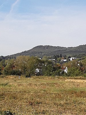
View of the Bilstein from the north-east, in the foreground is Großenritte |
||
| height | 460 m above sea level NHN | |
| location | near Besse , Schwalm-Eder-Kreis , Hesse ( Germany ) | |
| Mountains |
Langenberg / e , Habichtswälder Bergland |
|
| Coordinates | 51 ° 13 '37 " N , 9 ° 21' 16" E | |
|
|
||
| particularities | Ring wall and rock cliffs | |

The Bilstein is a little more than 460 m above sea level. NHN high elevation in the main ridge of the Habichtswälder Bergland and extensively wooded Langenberge in the north Hessian Schwalm-Eder district .
geography
location
The Bilstein, which extends the main ridge of the Langenberge, including Schwengeberg ( 556.7 m ), Laufskopf ( 534.8 m ) and Bensberg ( 464.8 m ), to the south-southeast, rises in the Habichtswald Nature Park between the villages Besse (to Edermünde ) in the east-southeast and Ermetheis (to Niedenstein ) in the west-northwest. It belongs especially to the area of the municipality of Edermünde, parts of its western flank belong to that of the city of Gudensberg . Its closest neighbor is the Bensberg , located around 650 m north-northwest . To the south, the landscape gradually flattens out in order to climb slowly to the Kammerberg to a height of 360.8 m .
Natural allocation
The Bilstein belongs in the natural spatial main unit group West Hessisches Bergland (No. 34), in the main unit Habichtswälder Bergland (342) and in the subunit Habichtswald (with Langenberg) (342.0) to the natural area Langenberg (342.02). The landscape falls to the west into the natural area Fritzlarer Börde (343.23 ), which is part of the subunit Hessengau (343.2) , and to the east into the subunit Kassel Basin (343.3), both of which are part of the main unit West Hessian Basin (343).
Flowing waters
The small Elsterbach flows west of the Bilstein, the water of which flows through the Matzoff, which ultimately strives to the south-west, to the Eder tributary Ems, and a little northeast of the elevation rises the pilgrim brook, which ultimately runs eastwards and flows directly into the Fulda tributary Eder.
Mountain height
According to the top contour line that can be seen on topographic maps , the Bilstein is a little more than 460 m high. A little to the east of its summit, topographic maps show a measuring point at an altitude of 459.4 m .
Others
A few meters southwest of the Bilstein summit is a small ring wall . Rocky cliffs spread out a little southeast of the summit; From a vantage point there and a refuge , the view falls particularly to the east and south-east. The Löwenweg hiking trail ( Warburg - Alsfeld ) leads across . In the unwooded, lower part of its east and south-east flanks, the localities of Am Battberg and Zum Rainsborn, which belong to Besse, are right next to each other . The Bilstein hiking car park is also located there .
Individual evidence
-
↑ a b c d Topographical hiking map Kassel-Steig - A panorama trail around the Kassel basin ;
M = 1: 31,250; 2 pages; 2012; Ed .: City of Kassel, surveying and geographic information - ^ Hans-Jürgen Klink: Geographical land survey: The natural space units on sheet 112 Kassel. Federal Institute for Regional Studies, Bad Godesberg 1969. → Online map (PDF; 6.9 MB)
- ↑ Water map service of the Hessian Ministry for the Environment, Climate Protection, Agriculture and Consumer Protection ( information )

