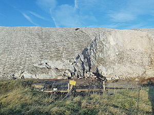
Inland salt station at the Ronnenberg potash plant
|
Inland salt station at the Ronnenberg potash plant
|
||
|
Edge of the spoil dump Ronnenberg with water surface |
||
| location | south of Ronnenberg in the Lower Saxony Region Hannover | |
| WDPA ID | 555518960 | |
| Natura 2000 ID | 3623-331 | |
| FFH area | 1.74 ha | |
| Geographical location | 52 ° 19 ' N , 9 ° 39' E | |
|
|
||
| Setup date | 2004 | |
The inland salt station at the Ronnenberg potash plant is a site registered as an FFH area and therefore protected in the Hanover region of Lower Saxony . The man-made inland salt station extends along the edge of the spoil dump of the former Ronnenberg potash plant .
geography
Natural allocation
The location is in the natural main unit group Lower Saxony Börden (No. 52), in the main unit Calenberger Lößbörde (521) and in the subunit Hannoversche Börde (521.0) in the natural area Benther Land (521.02).
location
A small ridge runs southeast of Ronnenberg, which includes the Gipsberg ( 90 m ) as a hill . The landscape slopes to the west. The overburden dump of the potash works on the southern edge of Ronnenberg is located on the slope about 25 meters below the summit.
geology
The Ronnenberg potash mine was one of the potash salt mines in the Benther salt dome area . This stretches about 8 km underground from the Ronnenberg district of Weetzen between Ronnenberg, Benthe , Empelde to the Hanoverian districts of Badenstedt and Davenstedt .
The salts of the Benther salt dome were deposited from the sea water in the Zechstein Age , 250 to 230 million years ago. The formerly flat layers were tectonically arched about 160 million years ago.
history
On March 28, 1898, the sinking of the Albert shaft on the edge of Ronnenberg began. Even the construction was hindered by several water inrushes, so that the production could not start until the end of 1905. By 1975 over 40 million t of material had been extracted and processed in a factory on the factory premises. About 90% of the overburden, consisting of rock salt, was deposited on a dump south of the shaft. After a severe water ingress in the summer of 1975, the mine was flooded and abandoned. Part of the spoil heap was later removed.
The rainwater that runs off the remaining stump of the heap absorbs salts and is collected in ring trenches at the bottom of the heap, in which mainly sulphate salts are deposited. The saturated salt solution is diluted with fresh water and conveyed to the foot via an approximately 8 km long pipeline . In this way, about 20 tons of salt per year get into the river.
A relatively narrow, 1.47 hectare protected area extends over a length of around 600 m on the south and east edges of the heap. Access to the entire area is prohibited by the Clausthal mining authority.
Other FFH areas
The inland salt station at the Ronnenberg potash plant is one of only two FFH areas in the area of the city of Ronnenberg , along with a piece of forest in Linderter and Stamstorfer Holz . Another inland salt station at the potash works in the Empelde district no longer exists after the ongoing recultivation of the spoil dump there.
See also
Web links
supporting documents
- ↑ Konrad Boden: Potash salt mining in Ronnenberg: How did salt come about? Ronnenberg local history museum, accessed on December 5, 2015 .
- ↑ cf. Monument inscription next to the former administration building, see photo
- ↑ Konrad Boden: Potash salt mining in Ronnenberg: Historical outline. Ronnenberg local history museum, accessed on December 5, 2015 .
- ^ Potash heaps. BUND Region Hannover, accessed on February 20, 2019 .
- ↑ Uwe Kranz: Menke doesn't want to be pilloried all the time. www.sn-online.de, December 23, 2018, accessed on February 20, 2019 .
- ↑ Landscape framework plan of the Hanover region. Status 2013. pdf; 16.4 MB. Hanover region. Environment department. Nature Conservation Team 36.04, 36.05 AG Landscape Framework Plan , pp. 511-514 , accessed on May 13, 2015 .
- ↑ Reconstruction of the landscape framework plan for the Hanover region. Information template (pdf; 7.4 MB). City of Ronnenberg, October 12, 2012, p. 13 , accessed December 8, 2015 .

