
Are
|
Are French : Bisten |
||
 Course of the bist |
||
| Data | ||
| Water code | FR : A96-0200 , DE : 26452 | |
| location |
France
|
|
| River system | Rhine | |
| Drain over | Saar → Moselle → Rhine → North Sea | |
| source | in the municipality of Bisten-en-Lorraine in France , Moselle department 49 ° 9 ′ 11 ″ N , 6 ° 35 ′ 50 ″ E |
|
| Source height | approx. 380 m | |
| muzzle | at Wadgassen in the Saar coordinates: 49 ° 16 ′ 22 ″ N , 6 ° 47 ′ 51 ″ E 49 ° 16 ′ 22 ″ N , 6 ° 47 ′ 51 ″ E |
|
| Mouth height | approx. 185 m | |
| Height difference | approx. 195 m | |
| Bottom slope | approx. 7.5 ‰ | |
| length | 26 km | |
| Discharge at the Uberherrn A Eo gauge : 112.8 km² |
MQ Mq |
1.13 m³ / s 10 l / (s km²) |
| Reservoirs flowed through | Lac de Creutzwald | |
 You're with advertising |
||
The bist ([ ˈbiːst ], regional [ ˈbiːʃt ]); historically also Biest or Biess is a river in France and Germany ( Saarland ) that flows into the Saar at Wadgassen . It rises in the municipality of Bisten-en-Lorraine in the Grand Est region , flows through the towns of Bisten-en-Lorraine, Varsberg , Ham-sous-Varsberg and Creutzwald in the Moselle department and the towns of Überherrn , Bisten , Differten , Werbeln in the Saarland , Schaffhausen and Wadgassen . It is not passable and has completely lost its original economic importance, operation of the abbey mills and water supplier for abbey manufacturers as well as the Wadgassen Cristallerie .
course
The Bist rises in the municipality of Bisten-en-Lorraine in Lorraine , Arrondissement Forbach-Boulay-Moselle , then flows for a little more than 10 kilometers in a north-east direction to the point where it crosses the border river Germany for about three kilometers. France educates. It passes the Lac de Creutzwald, created in 1967, as well as the town of Creutzwald itself. After its brief border marking, the Bist leaves France exactly at the point where the former, 70-kilometer-long railway line Völklingen - Überherrn - Hargarten-Falck - Diedenhofen crosses the border. The tracks are still there today, but the line is no longer served and long stretches have been left to decay.
On the German side Are flows to the west north of Ueberherrn over, through whose district Bisten , then close to the under monument protection standing farm and stud Linslerhof over before it Differten reached already to the municipality of Wadgassen belongs. In Differten, near the district of Werbeln, it bends to the north at a right angle. From here it forms the border between Wadgassen and its district of Schaffhausen. Immediately before it flows into the Saar, it passes under the Saarbrücken city motorway (A 620) .
The original course of the bistro in the Wadgassen area was changed to the current course at the time of the Wadgasser Abbey and can only be traced back to old drawings.
Historical meaning

The historical and economic importance of the Bist can be seen in the concrete example of the past of the Saarland community of Wadgassens. In combination with the extensive canal system, the bist was used to drain the area around the Premonstratensian monastery there, as well as irrigating the fields and operating the mills in Differten and Hostenbach, which are important for the region . The Cristallerie Wadgassen , which was later located there, would also have been inconceivable without the Bist, as the water required for production there was conveyed to the smelter site through the canal going off the Bist.
Are as namesake
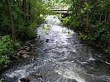
Directly recognizable in village names such as in French Bisten-en-Lorraine or Saarland Bisten. Indirectly, for example, in the names of the two Wadgasser parts of the municipality Differten (also: Diefurt, Diffurde, Diffurte, Diffurthe, Diffurt, Diffurten), i.e. “zur deep ford” and Werbeln , derived from the Middle High German word “Wirbel” or “Werbel” Name of a prominent part of the bistro, where turbulence used to occur due to a very steep gradient in relation to the rest of the course; similar to line 1, picture 3.
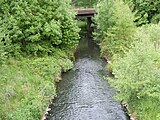
gallery
- The bist

Source of the bishopric around 1901
Wadgassen near the market square
At Wadgassen just before the estuary

Under the A 620 at Wadgassen

Estuary into the Saar

Estuary into the Saar


Web links
- museum.academia-wadegotia.de (video as well as images and texts about the bist)
- Humor: The ultimate proof that rivers only flow one way - especially the Bist
- Débits caractéristiques de la Bisten (French; PDF; 14 kB)
Individual evidence
- ↑ Source geoportail.gouv.fr
- ↑ Rhine-Meuse water data of the Direction Régionale de l'Environnement, de l'Aménagement et du Logement Lorraine (French) ( Notes
- ↑ see: Bist Canalis in the engraving of the Wadgasser Abbey
- ↑ wadgassen through the ages. Wadgassen, 2016, archived from the original on March 4, 2016 ; accessed on June 4, 2019 (original website no longer available).
- ↑ section of the route Werbeln-Differten. Retrieved May 10, 2010 .
- ↑ edited photo of Erich Hewers and Rudolf Fuchs' poster "Unser Bist" , 1974; similarly published in: "Habitat in the Valley of the Bist" .