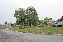
Božec
| Božec | ||||
|---|---|---|---|---|
|
||||
| Basic data | ||||
| State : |
|
|||
| Region : | Středočeský kraj | |||
| District : | Kolín | |||
| Municipality : | Krakovany | |||
| Area : | 281 ha | |||
| Geographic location : | 50 ° 4 ' N , 15 ° 22' E | |||
| Height: | 245 m nm | |||
| Residents : | 84 (2011) | |||
| Postal code : | 281 27 | |||
| License plate : | S. | |||
| traffic | ||||
| Street: | Krakovany - Žiželice | |||
Božec (German Boschetz ) is a district of the municipality Krakovany in the Czech Republic. It lies four kilometers north of Týnec nad Labem and belongs to the Okres Kolín .
geography
Božec is located on a hill in the Středolabské tabule (table land on the middle Elbe ). The Předveský creek rises in the village, it feeds a cascade of six ponds and pools on the southern edge of the village. The source of the Svárava is located northeast of the village. The Čížovka (251 m nm) rises in the north.
Neighboring towns are Lipec in the north, Kundratice, Rasochy and Uhlířská Lhota in the Northeast, Hlavečník the east, Selmice the southeast, Krakovany and Týnec nad Labem in the south, Veletov and Konárovice in the southwest, Bělušice , Chrást and Němčice in the west and Ohaře , Polní Chrčice and Dománovice in the northwest.
history
The first written mention of Božec was in 1371 as the property of Vladiken Čeněk of Kosice. The following landlords were Jan Korček von Božec and his descendants. Later the Lords Slavata von Chlum and Koschumberg acquired the village. Subsequently, the village belonged to the Klusák von Kostelec family who sold their inheritance to King Rudolf II at the end of the 16th century . This united the estate in 1607 with the rule Podebrady .
In 1833 the rustic village of Boschek or Božek in the Bijov district consisted of 24 houses in which 151 people, including three Protestant families, lived. Boschek was one of the five villages of the Chrchitzer or Upper Court. The village was assigned to the Catholic branch church in Lipetz (Parish Elbe-Teinitz ), the school location was Krakowan . The inhabitants lived from agriculture, mainly chicories were grown. Until the middle of the 19th century Boschek remained subordinate to the kk cameraman Podiebrad.
After the abolition of patrimonial Božce formed from 1849 a district of the municipality Lipec in the judicial district of Chlumetz . From 1868 the village belonged to the Neubydžow district . In 1869 Božce had 188 inhabitants and consisted of 35 houses. In 1900 there were 189 people in Božce , in 1910 there were 227. In 1921 Božce broke away from Lipec and formed its own municipality. Božec has been used as a place name since 1924 . In 1930 Božec had 180 inhabitants. In the course of the territorial reform of 1960 Božec was assigned to the Okres Kolín. In 1961 it was incorporated into Krakovany. In the 2001 census, 104 people lived in Božec's 43 houses.
Community structure
The district of Božec forms a cadastral district.
Attractions
- Liberation Monument
- Stone cross and bell tree on the village square
- Robovský oak, tree monument
literature
- Historický lexikon obcí České republiky 1869–2005 , part 1, p. 106
Web links
Individual evidence
- ↑ Katastrální území Božec: Územně identifikační registr ČR. In: uir.cz. Retrieved January 31, 2019 (Czech).
- ^ Johann Gottfried Sommer : The Kingdom of Bohemia; Represented statistically and topographically. Volume 3 Bidschower Kreis. Calve, Prague 1835, p. 76.
- ↑ Část obce Božec: Územně identifikační registr ČR. In: uir.cz. Retrieved January 31, 2019 (Czech).


