
Týnec nad Labem
| Týnec nad Labem | |||||
|---|---|---|---|---|---|
|
|||||
| Basic data | |||||
| State : |
|
||||
| Region : | Středočeský kraj | ||||
| District : | Kolín | ||||
| Area : | 1569 ha | ||||
| Geographic location : | 50 ° 3 ' N , 15 ° 21' E | ||||
| Height: | 243 m nm | ||||
| Residents : | 2,063 (Jan 1, 2019) | ||||
| Postal code : | 281 26 | ||||
| License plate : | S. | ||||
| structure | |||||
| Status: | city | ||||
| Districts: | 3 | ||||
| administration | |||||
| Mayor : | Josef Polák (as of 2007) | ||||
| Address: | Masarykovo náměstí 1 281 26 Týnec nad Labem |
||||
| Municipality number: | 533807 | ||||
| Website : | www.tynecnadlabem.cz | ||||


Týnec nad Labem , around 1900 Labska Tynice , ( German Elbeteinitz ) is a small town with around 1,900 inhabitants. It is located in Okres Kolín , Středočeský kraj , Czech Republic - about 10 km from the district town of Kolín.
Districts
Districts are Týnec nad Labem ( Elbeteinitz, older also Theinitz an der Elbe), Lžovice ( Lzowitz ) and Vinařice ( Winarzitz ).

Attractions
The house with the number 2 dates from 1584.
The Marian column, the cemetery chapel, the St. John's Church and the town hall as well as the grave of General von Melas date from the second half of the 18th century .

St. John's Church
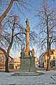
Marian column

Tomb of the general of Melas


Personalities
- Michael Friedrich Benedikt Freiherr von Melas (1729–1806), Austrian general
Web links
Commons : Týnec nad Labem - collection of images, videos and audio files
Individual evidence
- ↑ Český statistický úřad - The population of the Czech municipalities as of January 1, 2019 (PDF; 7.4 MiB)
- ↑ Antonín Profous : Místní jména v Čechách. Jejich vznik, původ, význam a změny. Volume 1-5. Česká akademie věd a umění, Prague 1947–1960.