
Bourtange
| province |
|
| local community | Westerwolde |
|
Area - land - water |
8.69 km 2 8.31 km 2 0.38 km 2 |
| Residents | 640 (Jan. 1, 2017) |
| Coordinates | 53 ° 0 ′ N , 7 ° 12 ′ E |
| Important traffic route |
|
| prefix | 0599 |
| Postcodes | 9541, 9545 |

Bourtange is an inhabited former fortress in the Netherlands . It is located in the Dutch province of Groningen , two kilometers from the German-Dutch border near Dörpen . Bourtange belongs to Westerwolde , whose part of the municipality Vlagtwedde therefore has a cannon in its coat of arms .
The fortress encloses the fortified city of the same name with its outer works . It is one of the few fortresses in Europe that has been rebuilt after its almost complete decline in recent decades. The system was used to monitor the few roads and paths in this previously completely boggy landscape. The Bourtanger Moor , on both sides of the border, is named after the fortress.
history
The construction of the fortress on behalf of William I of Orange began in 1580 during the Eighty Years' War at the exact point where two ox carts were able to avoid each other on the way between Heede an der Ems and Groningen through the moors and swamps . It was hoped that this would cut off the Spanish-occupied city of Groningen from the outside world.
The fortress was completed in 1593 and changed over and over again in the course of the Thirty Years War and adapted to the respective technical conditions. During this war and in the restless decades that followed, it could never be conquered by an attacker.
In the following decades the fortress was repaired during times of crisis and then fell into disrepair. In 1742 it reached its greatest extent during the First Silesian War . It was of military importance until the middle of the 19th century. In the war-free times, more and more citizens settled in the inner fortress area, so that over time a small fortress town emerged.
In 1851 the fortress was officially given up militarily. The village flourished and grew to a stately size. After the Second World War , more and more residents left the village due to poor infrastructure in the entire province. In 1960 it was about to be completely abandoned.
reconstruction
The then municipality of Vlagtwedde then decided to revitalize the area and save the fortress to the status of 1742 - when the fortress had reached its largest size - to rebuild it as a museum and leisure site, which also reflects the remote location of the complex is due. Therefore, a fortress can be visited at this point today, which shows a very rare structural condition.
The fortress itself is a completely regular pentagon with bastions at the corners . However, the distance from bastion point to bastion point is only 200 m. At the time of construction, this was a normal range of the infantry weapons of the time . Furthermore, water-filled trenches, ravelins , a crown work and a glacis are in front of the core fortress . The complex consists mainly of earth and wood, only the two gate structures and a short postern are bricked.
The most important restoration work took place between 1964 and 1973, and the system was regularly supplemented and expanded afterwards.

View from a bastion into the moat

Cannon position on one of the bastions

Munster Gate and drawbridge of Bourtange Fortress

Detail of the Munster Gate


Church in the fortress
View of the synagogue and market

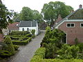
Town center

Post mill


Torture horse in the market square

Kerstmarktzeit (Christmas market time) in the fortress

Model of the fortress Bourtange in the Leeraner Miniaturland

The only way to get inside the fortress is via drawbridges


Museum village
Today's museum village Bourtange is a tourist attraction within the fortress pentagon.
The fortress city is surrounded by ramparts and moats, protected by bridge guard houses and houses typical contemporary houses, such as the "Capiteynslogement" , the house of the steward ( "Convooimeester" ) and other officers' houses, spice houses, the church, various mills, the defenses including cannons and Gunpowder warehouse and the "Secreten" (former toilet facility ).
There is also the restored synagogue in Bourtange from 1842 , which served as a house of prayer for the Jews living in the area until the Second World War. During the war, all of Bourtange's Jewish residents were deported ; only two of them returned. The prayer house is set up as a synagogue museum and is the only well-preserved synagogue along the Dutch-German border.
In addition to an information center, various museums, restaurants and cafés, the "fortress logementen" also houses a hotel.
future
In the Middle Ages , the area around the fortress city was an extensive and inaccessible swamp area. Since 2003 work has been carried out to rewet these areas, which have been reclaimed in the meantime, in order to achieve an even more authentic state. The project is called “De Natte Horizon” (The Wet Horizon). The swamp area made it easier to defend against the enemy because of its inaccessibility and the difficulty of setting up artillery in the immediate vicinity of the fortress. Now the area is to become a nature reserve and can be reached on hiking and cycling trails and on the canals with excursion boats.
Living history
In the summer months, several events take place that bring the past of the fortress back to life: In the season from mid-March to mid-October, pikemen and musketeers drill on the main square every Sunday afternoon . Afterwards, gunners load and fire a cannon on the ramparts .
Since 1996 "the Battle of Bourtange" has been re-enacted on the first weekend in May. The battles of 1640 (uneven years) and 1814 alternate annually. In the middle of August the big "Fortress Spectaculum" takes place, a journey back in time to the Middle Ages and the Renaissance. A magical festival takes place at the end of October, the “Kerstmarkt” ( Christmas market ) on the first three Advent weekends, plus several markets throughout the year.
Exercising of pikemen and musketeers
Load and fire a cannon


Web links
- Bourtange Fortress website (Dutch, German, English)
- Interview with a fortress guide about the history of Bourtange YouTube (German)
- Pictures from the Bourtange fortress
Individual evidence
- ↑ Kerncijfers wijken en buurten 2017 Centraal Bureau voor de Statistiek , accessed on June 29, 2018 (Dutch)