Brückenbach (Oker)
| Brückenbach | ||
|
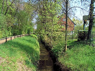
Brückenbach am Unterlauf in Groß Stöckheim, viewing direction is direction of flow, on the left is the pond area. |
||
| Data | ||
| Water code | DE : 48272 | |
| location | Lower Saxony , Germany | |
| River system | Weser | |
| Drain over | Oker → Aller → Weser → North Sea | |
| source |
Oderwald near Leinde 52 ° 8 ′ 6 ″ N , 10 ° 28 ′ 37 ″ E |
|
| Source height | 130 m | |
| muzzle |
Groß Stöckheim coordinates: 52 ° 10 ′ 31 ″ N , 10 ° 31 ′ 21 ″ E 52 ° 10 ′ 31 ″ N , 10 ° 31 ′ 21 ″ E |
|
| Mouth height | 74 m | |
| Height difference | 56 m | |
| Bottom slope | 5.3 ‰ | |
| length | 10.5 km | |
| Catchment area | 27.45 km² | |
| Left tributaries | Immendorfer Bach | |
| Right tributaries | Adersheimer Graben, Breite Riede | |
| Medium-sized cities | Salzgitter , Wolfenbüttel | |
| Water body 15032 | ||
The Brückenbach is a ten kilometer long left tributary of the Oker , which mainly runs in the Wolfenbüttels area. It rises in Leinde on the slope of the Oderwald and flows into the Oker near Groß Stöckheim .
course
The source of the Brückenbach is recorded on the northwestern edge of the Oder forest, which slopes gently to the west, near the L495 road, where it appears as a small Feldbach. He leaves Leinde, which belongs to the city of Wolfenbüttel, to the south and turns north towards SZ-Immendorf . It passes under the Braunschweig-Kreiensen railway line and the intersection of the B248 with the L295 road. In Immendorf it turns to the northeast and runs through meadows towards Drütte , where it fills flax rotten on the outskirts . It crosses under the B248 and leaves the Salzgitteraner area to Wolfenbüttel. As a straight Feldbach it reaches Fümmelse , where it takes up the Breite Riede from the right , passes the place south in new building areas and then turns slightly to the southeast.
It runs through the Feldmark, is crossed by the A36 and bends north in the direction of the Alte Ziegelei , where the Fümmelsee natural swimming pool, created from a former clay pit, is located. In this section it is bordered by meadows rich in trees below the rain compensation basin. In the further course it flows north of an allotment garden through the field mark of Groß Stöckheim, where it is called Mühlengraben in historical maps , crosses the railway line Braunschweig-Wolfenbüttel, runs along the street Am Bache through the settlement area and reaches an old gardener's house. A partial stream is branched off to the left for the cultivation of the Groß Stöckheimer pond, while the Brückenbach flows in a straight line to the Oker.
Catchment area
On the western edge of the Oderwald, the Fuhse rises south of the bridge brook , which also takes in other brooks on the western slope. The Brückenbach, on the other hand, bends east in front of the slight hills between Salzgitter-Watenstedt and Beddinger Holz and reaches the Oker. It records the runoff from the northern Oder forest area.
Attractions
The flax rotten planted in Drütte in 1650 is pointed out with a board set up in 2009. They are located directly on the path and are easily visible. After the flax cultivation was abandoned, the small ponds were used as “sheep baths”.
The Berlin-Hameln long-distance cycle path runs parallel to the Brückenbach stream from the Oderwald downwards.
Web links
Individual evidence
- ↑ a b Topographic map 1: 50,000 of the state of Lower Saxony
- ↑ a b NLWKN : Inventory of the implementation of the EC Water Framework Directive, Oker processing area , Braunschweig November 2004, Table 3.
- ↑ LGN : Historical Maps 1872-1911 at navigator.geolife.de , accessed July 12, 2013 from the LGN website ( Memento of the original from March 19, 2015 in the Internet Archive ) Info: The archive link was inserted automatically and has not yet been checked. Please check the original and archive link according to the instructions and then remove this notice.
