Brennersee
| Brennersee | ||
|---|---|---|

|
||
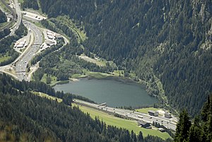
| Brennersee with houses Brennersee and Brenner autobahn | ||
| Geographical location | Tyrol , Wipptal | |
| Tributaries | Sill , Vennbach | |
| Drain | Sill | |
| Location close to the shore | Gries am Brenner , Brenner | |
| Data | ||
| Coordinates | 47 ° 1 '5 " N , 11 ° 30' 14" E | |
|
|
||
| Altitude above sea level | 1311 m above sea level A. | |
| surface | 5.5 ha | |
| length | 350 m | |
| width | 200 m | |
The Brennersee is about 1.15 km north of the Brenner Pass at an altitude of 1311 m above sea level. A. With an area of approx. 5.5 hectares, it is the largest lake in the Wipptal . The lake can be reached by the Brenner motorway or by regional train from Innsbruck .
Although the lake is generally open for swimming, the water barely warms up to more than 12 ° C, even in midsummer. In addition, the lake is very shady, which makes it cool in the surrounding area. The Sill supplies the lake with fresh water and drains it at the same time. The cold water fluctuates between water quality classes I to II and is home to various carp and trout species . A carpet of algae on the bottom usually colors the water jade green.
The group of the same name from the municipality of Gries am Brenner is also located on the Brennersee . A little away from the lake, towards the top of the pass, lies the abandoned Brennersee station of the Brennerbahn .
|
|
||||||||||||||||||||||
Web links
Individual evidence
- 70313 - Gries am Brenner. Community data, Statistics Austria .


