Bristol County, Massachusetts
 Bristol County Courthouse |
|
| administration | |
|---|---|
| US state : | Massachusetts |
| Administrative headquarters : | Taunton |
| Foundation : | 1685 |
| Demographics | |
| Residents : | 548,285 (2010) |
| Population density : | 380.8 inhabitants / km 2 |
| geography | |
| Total area : | 1790 km² |
| Water surface : | 350 km² |
| map | |
| Website : www.countyofbristol.net | |
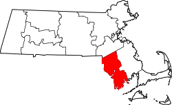
The Bristol County is a county in the state of Massachusetts of the United States . The county seat is Taunton .
geography
The county has an area of 1790 square kilometers, of which 350 square kilometers are water. It is bordered clockwise by the following counties: Norfolk County , Plymouth County , Newport County (Rhode Island), Bristol County (Rhode Island), and Providence County (Rhode Island).
history
Bristol County was one of three founding counties of Plymouth Colony in 1685 .
Twelve sites in Bristol County have National Historic Landmarks due to their historical significance , including the former expedition ship Ernestina , the destroyer USS Joseph P. Kennedy, Jr. , the submarine USS Lionfish , the battleship USS Massachusetts and the former whaling center New Bedford Historic District .
Population development
| 1980 | 1990 | 2000 | 2010 |
|---|---|---|---|
| 474,345 | 506.325 | 534.678 | 548.285 |
Demographics
According to the 2000 census , Bristol County's population was 534,678 in 205,411 households and 140,706 families. The population was 90.98 percent white, 2.03 percent African American, 1.26 percent Asian, and 0.24 percent Native American. Hispanic or Latino of any race were 3.60 percent of the population. The per capita income was $ 20,978; 7.8 percent of families and 10.0 percent of the population lived below the poverty line .
cities and communes
See also
Web links
Individual evidence
- ^ Extract from the National Register of Historic Places.Retrieved March 13, 2011
- ↑ GNIS-ID: 606929. Accessed on February 22, 2011 (English).
- ^ National Association of Counties.Retrieved February 19, 2011
- ↑ Listing of National Historic Landmarks by State: Massachusetts . National Park Service , accessed November 16, 2017.
- ^ Bristol County, Massachusetts , 2000 census data sheet at factfinder.census.gov .
Coordinates: 41 ° 45 ′ N , 71 ° 5 ′ W

