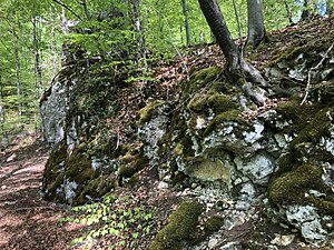
Rauhaus Castle
| Rauhaus Castle | ||
|---|---|---|
|
Remains of the Rauhaus Castle |
||
| Creation time : | probably around 1200 | |
| Castle type : | Höhenburg, spur location | |
| Conservation status: | Burgstall | |
| Place: | Ederheim -Christgarten | |
| Geographical location | 48 ° 47 '6 " N , 10 ° 27' 38.9" E | |
| Height: | 540 m above sea level NN | |
|
|
||
The Rauhaus Castle is a long-lost high medieval aristocratic castle of the noble lords of Hürnheim above the former Christgarten monastery in the Kartäusertal near Nördlingen in the Bavarian-Swabian district of Donau-Ries in Bavaria .
The castle stable is freely accessible at all times.
Geographical location
The former spur castle is located in the municipality of Ederheim , about 2.5 kilometers southwest of Hürnheim on the Thannhalde, a south-east facing foothill of the Blankenstein at about 540 meters above sea level in a slope spur. It is located about 50 meters above the former Christgarten monastery and the confluence of two streams in the Forellenbach.
There are numerous other fortifications in the vicinity: on the opposite side of the valley a semicircular hill on the Mühlberg, a large ring wall on the Weiherberg , at the exit of the Kartäusertal lies the Hochhaus castle ruins and opposite the Hagburg ramparts , an early medieval fortification, and the Niederhaus castle ruins .
history
In 1238 the castle Rauhaus for the first time as "castrum" owned by the Edelfreien family of Hürnheim-Rauhaus , a branch of the lords of Hürnheim with its headquarters Castle Lower House , mentioned. It was probably built around or shortly after the year 1200. Shortly before 1262 the family migrated from Rauhaus Castle to Katzenstein Castle, which they acquired . There this branch expired in 1419 with Georg von Hürnheim-Rauhaus-Katzenstein . Rauhaus Castle was probably abandoned at the latest at the end of the 13th century after the lords of the castle left and slowly fell into disrepair. Parts of the outer bailey fell victim to a landslide on the west side. Today the Burgstall is located in the middle of a private game reserve and bears the monument number D-7-7228-0017.
description
The castle complex lies on a slope that slopes steeply on three sides and is divided into a bailey in the north-western part and a main castle at the tip of the spur . It was about 230 meters long and 60 to 120 meters wide.
On the north-west side of the castle, a double wall system about 135 meters long protected the outer bailey. This double wall is still up to 1.7 meters high and arched over the entire spur. A gap in the middle is a modern breakthrough.
The southwest flank of the mushroom-shaped outer bailey may have slipped as early as the High Middle Ages; there was probably a smaller outer bailey there before. From the western end of the double wall, a 120-meter-long, second double wall stretches along the outer bailey in an arc to the southeast and ends a few meters in front of a short, 5-meter-deep neck ditch .
The approximately 60 by 60 meter large main castle was divided into an upper castle on an approximately 13 meter high, artificially carved, formerly square earth cone, and a 10 to 20 meter wide lower castle located on the west to east side of the earth cone. On the approximately 28 by 22 meter large upper castle there was probably a 13 meter wide and 15 to 18 meter long tower house, of which the foundation wall traces and rubble bars are still visible.
Whether the tower hill was subsequently added to an older castle complex or whether the outer bailey was built at the same time as the main castle cannot be decided with certainty. The gate seems to have been to the northwest in front of the tower hill. In the east this terrace is only about two meters wide and allows access to the outer bailey.
literature
- Hans Frei, Günther Krahe (ed.): Guide to archaeological monuments in Bavaria - Swabia Volume 2: Archaeological walks in the Ries . 2nd edition, Konrad Theiss Verlag, Stuttgart and Aalen 1988, ISBN 3-8062-0568-X , pp. 240–242.
- Günter Schmitt : Castle Guide Swabian Alb, Volume 6 - Ostalb: Hiking and discovering between Ulm, Aalen and Donauwörth . Biberacher Verlagsdruckerei, Biberach 1995, ISBN 3-924489-74-2 , pp. 187-192.
- Wilfried Sponsel, Hartmut Steger: Past castles and mansions: A search for traces in the view of the Ries . Typesetting and Graphics Partner GmbH, Augsburg 2004, ISBN 3-935438-27-3 , pp. 28-33.


