
Saxenegg castle ruins
| Saxenegg castle ruins | ||
|---|---|---|
 1. A strong ashlar tower. 2. A cistern. 3. Old kennel. 4. Atrium. 5. Saxenegger Forest. Engraving by Clemens Beuttler. |
||
| Creation time : | 13th Century | |
| Castle type : | Hilltop castle | |
| Conservation status: | ruin | |
| Place: | St. Thomas on the bladder stone | |
| Geographical location | 48 ° 17 '56 " N , 14 ° 44' 25" E | |
| Height: | 530 m above sea level A. | |
|
||

Burgruine Saxenegg is a badly dilapidated former castle complex in the municipality of St. Thomas am Blasenstein in the Perg district in the Mühlviertel in Upper Austria . The village of the same name is located southwest of the castle ruins in the area of the cadastral community of Innernstein in the market town of Münzbach and consists of smaller settlements and scattered houses. The name Saxenegg comes from the old name of Saxony , today's Käfermühlbach , which flows into the Naarn near Saxen and immediately afterwards into the Danube .
location
The ruins of the hilltop castle are located on a wooded hilltop that slopes sharply to the south, east and west at 530 m above sea level. A. Elevation between the Käfermühlbach and Rechbergerbach streams . The facility is located in a south-westerly direction around 2.3 km (as the crow flies) from the center of St. Thomas, just on the municipal border with Münzbach . The castle ruins can be reached via the village of Saxenegg, which belongs to Münzbach .
description
The total converted area of the former hilltop castle was 1,707 m². The main castle , consisting of Palas and keep , lay on a projecting south rocky outcropping . To the north, the lower-lying, later built outer bailey was connected , which could be reached from the core bailey via a drawbridge and which in turn was secured by a wide and deep neck ditch on the northern slope side . Only the remains of the wall remain of the complex, which is now in the forest, in particular the towering former north wall of the keep.
history
The exact time when Saxenegg Castle was built is not known. It was first mentioned in a document on March 12, 1297. Ulrich and Wernhart the Sechseneker were named as owners at that time . In 1342 Duke Albrecht II gave Castle Saxenegg Burghart to the Kneusser as a fief . In 1382 Hans der Kneusser sold the facility to Duke Albrecht III. At that time, 14 farms, 22 ½ fiefs and 23 farms in the surrounding parishes belonged to the Saxenegg lordship . Thereafter the rulership changed its fiefdom several times: first it went to Wolf the Schenk von Dobra, in 1403 to Hans den Ruckendorfer, in 1405 to Albrecht the Schweinwarter, and in 1410 to the brothers Erhard and Wilhelm von Zelking.
The family of the Zelkingers remained in the possession of Saxenegg until King Albrecht on May 26th 1438 allowed them “ the vest six, which is somewhat pawfellig as we deny and do not deny to help our people in (him). “From this date the castle was largely abandoned, and Christoph von Zelking bequeathed the inventory of the castle chapel to the parish church of Kefermarkt in 1473 . The rule Saxenegg, which included also Nutzrechte to surrounding area, such as on water (fishing), forestry (wood) or the Wild spell , was in 1493 by the brothers Prüschek on Greinburg acquired in 1525, the property was to the widow Anna baroness of Prague her sons. The rulership was from then on administered by the Windhaag rulership until the land authority was abolished in 1848. This year, the citizens of Münzbach are said to have organized a freedom festival at the foot of the former castle.
Picture gallery
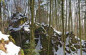
Behind the neck ditch the outer bailey and then the keep. Seen from the north.

Keep from the north. Under the rock the forecourt with the cistern.

Cistern - frozen over.
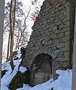
Round arch in the east of the keep.

Keep from the south. It only consists of the north wall.


See also
literature
- Herbert Erich Baumert, Georg Grüll : Castles and palaces in Upper Austria. Volume 1: Mühlviertel and Linz. Vienna 1988, pp. 168-170.
- Norbert Grabherr : Castles and palaces in Upper Austria. Oberösterreichischer Landesverlag, Linz 1970, p. 260 (Sachsenegg).
- Working group Josef Grafeneder: Münzbach, country and people - yesterday and today. Edited by the market town of Münzbach. Moserbauer printing works, Ried im Innkreis 2010, ISBN 978-3-902684-17-2 , p. 126 (Sachseneck).
- Herbert Hiesmayr: St. Thomas on the bladder stone. Edited by the St. Thomas Tourist Association. Plöchl printing works, Freistadt 1991, p. 89 (Saxenegg castle ruins).
Web links
- Floor plan of the castle ruins
- Saxenegg at Burgenkunde.at
- Online report about a castle visit on saelde-und-ere.at.
Individual evidence
- ↑ a b Karl Hohensinner , Peter Wiesinger : The place names of the political districts Perg and Freistadt (Eastern Mühlviertel). Austrian Academy of Sciences, Vienna 2003, pp. 66–67.
- ↑ Her Weich the Holzer von Clam gives the light in the Baumgartenberg church a fiefdom to Weisching and a court act to Ganng as a Seelgeräth . In: Upper Austrian document book . Volume 4, no. CCLXXVIII, March 12, 1297, p. 251 ("her Vlrich and her Wernhart diehexenecker" as witnesses; from the copy book of the Baumgartenberg monastery , 1511).